Cupareo geodata
Cupareo (Guanajuato) is a populated place; located in Mexico in America/Mexico_City (GMT-6) time zone. With population of 2,061 people, there are 4233 cities with bigger population in this country. Compared to other cities in Mexico, 62% of cities are located further ↓South; 73.6% of cities are located further →East and 60.6% of cities have lower elevation than Cupareo. Note1


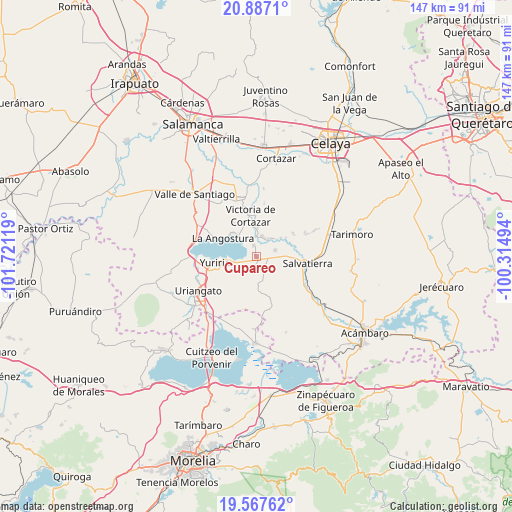
Cupareo GPS coordinates[2]
20° 13' 43.536" North, 101° 1' 5.016" West
| Map corner | latitude | longitude |
|---|---|---|
| Upper-left | 20.8871°, | -101.72119° |
| Center: | 20.22876°, | -101.01806° |
| Lower-right: | 19.56762°, | -100.31494° |
| Map W x H: | 146.7×146.7 km | = 91.2×91.2mi |
| max Lat: | 32.7° ⇑38% North |
| Cupareo: | 20.22876° |
| min Lat: | ⇓62% South 14.53588° |
| min Long | Cupareo | max Long |
| -117.105° | -101.01806° | -86.73105° |
| W 26.4%⇐ | ⇒73.6% E |
Elevation
Elevation of Cupareo is 1735 m = 5692 ft, and this is 481.3 m = 1579 ft above average elevation for this country.
| Max E: |
3497 m = 11473 ft | 39.4% |
| Cupareo | 1735 m 5692 ft | |
| Avg. | 1253.7 m = 4113 ft | |
Min E: |
-1 m = -3 ft | 60.6% |
See also: Mexico elevation on elevation.city.
Geographical zone
Cupareo is located in North Torrid zone (between Equator and Tropic of Cancer). Distance of this Northern Tropic circle is 356.7 km =221.6 mi to North.| Distance of | km | miles | from Cupareo |
|---|---|---|---|
| North Pole | 7757.8 | 4820.5 | to North |
| Arctic Circle | 5151.9 | 3201.2 | to North |
| Tropic Cancer | 356.7 | 221.6 | to North |
| Equator | 2249.2 | 1397.6 | to South |


Nearby cities:
15 places around Cupareo: (largest is in red/bold)
• Cervacio Mendoza
2.5 km =1.6 mi,  195°
195°
• El Capulín
6.2 km =3.9 mi,  33°
33°
• El Potrero
8.4 km =5.2 mi,  61°
61°
• El Sabino
6.1 km =3.8 mi,  15°
15°
• Loma de Zempoala
9.6 km =6 mi,  317°
317°
• Maravatío del Encinal
6.4 km =4 mi,  114°
114°
• Puerta del Monte
3.4 km =2.1 mi,  346°
346°
• Rancho de Guadalupe
8.9 km =5.5 mi,  51°
51°
• San Nicolás de los Agustinos
5.7 km =3.5 mi,  70°
70°
• San Pedro de los Naranjos
8.4 km =5.2 mi,  91°
91°
• Santa Rita de Casia
4.7 km =2.9 mi,  136°
136°
• Santa Teresa (La Majada)
7.8 km =4.8 mi,  129°
129°
• Santiago Capitiro
8.4 km =5.2 mi,  0°
0°
• Santiago Maravatío
6.7 km =4.2 mi,  158°
158°
• Tinaja de Pastores
5.7 km =3.5 mi,  233°
233°
Sources, notices
• [Note1] Compared only with cities in Mexico existing in our database
• [Src1] Map data: © OpenStreetMap contributors (CC-BY-SA)
• [Src2] Other city data from geonames.org with taken over terms of usage.
• [Src3] Geographical zone / Annual Mean Temperature by Robert A. Rohde @ Wikipedia
