San Martín Ocoxochitepec (San Martín) geodata
San Martín Ocoxochitepec (San Martín) (State of Mexico) is a populated place; located in Mexico in America/Mexico_City (GMT-6) time zone. With population of 574 people, there are 14926 cities with bigger population in this country. Compared to other cities in Mexico, 59.4% of cities are located further ↑North; 67% of cities are located further →East and 60% of cities have lower elevation than San Martín Ocoxochitepec (San Martín). Note1
Current local time in San Martín Ocoxochitepec (San Martín):
07:05 AM, WednesdayDifference from your time zone: hours


San Martín Ocoxochitepec (San Martín) GPS coordinates[2]
19° 16' 12.576" North, 100° 15' 40.104" West
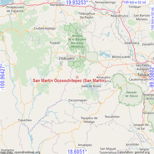
| Map corner | latitude | longitude |
|---|---|---|
| Upper-left | 19.93253°, | -100.96427° |
| Center: | 19.27016°, | -100.26114° |
| Lower-right: | 18.6051°, | -99.55802° |
| Map W x H: | 147.6×147.6 km | = 91.7×91.7mi |
| max Lat: | 32.7° ⇑59.4% North |
| San Martín Ocoxochitepec (San Martín): | 19.27016° |
| min Lat: | ⇓40.6% South 14.53588° |
| min Long | San Martín Oco | max Long |
| -117.105° | -100.26114° | -86.73105° |
| W 33%⇐ | ⇒67% E |
Elevation
Elevation of San Martín Ocoxochitepec (San Martín) is 1726 m = 5663 ft, and this is 472.3 m = 1550 ft above average elevation for this country.
| Max E: |
3497 m = 11473 ft | 40% |
| San Martín Ocoxochitepec (San Martín) | 1726 m 5663 ft | |
| Avg. | 1253.7 m = 4113 ft | |
Min E: |
-1 m = -3 ft | 60% |
See also: Mexico elevation on elevation.city.
Geographical zone
San Martín Ocoxochitepec (San Martín) is located in North Torrid zone (between Equator and Tropic of Cancer). Distance of this Northern Tropic circle is 463.3 km =287.9 mi to North.| Distance of | km | miles | from San Martín Ocoxochitepec (San Martín) |
|---|---|---|---|
| North Pole | 7864.4 | 4886.7 | to North |
| Arctic Circle | 5258.5 | 3267.5 | to North |
| Tropic Cancer | 463.3 | 287.9 | to North |
| Equator | 2142.6 | 1331.3 | to South |


Nearby cities:
15 places around San Martín Ocoxochitepec (San Martín): (largest is in red/bold)
• Barrio Chiquichuca
7.6 km =4.7 mi,  41°
41°
• Barrio de Arriba de San Juan Xoconusco
5.7 km =3.5 mi,  350°
350°
• Dolores (Ex-Hacienda de Dolores)
9.4 km =5.8 mi,  250°
250°
• Ejido de Miahuatlán
5.8 km =3.6 mi,  330°
330°
• El Aventurero
6.3 km =3.9 mi,  49°
49°
• Ixtapan del Oro
0.9 km =0.6 mi,  204°
204°
• Mesas Altas de Xoconusco
7.3 km =4.5 mi,  12°
12°
• Mesas de San Jerónimo
8.8 km =5.5 mi, 44°
• Miahuatlán de Hidalgo (Santa Cruz Miahuatlán)
4.8 km =3 mi,  316°
316°
• San Jerónimo Totoltepec
7.9 km =4.9 mi, 50°
• San Juan Xoconusco
4.6 km =2.9 mi,  2°
2°
• San Nicolás Tolentino
9.7 km =6 mi,  167°
167°
• Santa Teresa Tiloxtoc
8 km =5 mi,  125°
125°
• Santiago Huitlapaltepec
6 km =3.7 mi,  72°
72°
• Tutuapan
3.8 km =2.4 mi,  190°
190°
Sources, notices
• [Note1] Compared only with cities in Mexico existing in our database
• [Src1] Map data: © OpenStreetMap contributors (CC-BY-SA)
• [Src2] Other city data from geonames.org with taken over terms of usage.
• [Src3] Geographical zone / Annual Mean Temperature by Robert A. Rohde @ Wikipedia
