Quimichis geodata
Quimichis (Nayarit) is a populated place; located in Mexico in America/Mazatlan (GMT-7) time zone. With population of 3,409 people, there are 2667 cities with bigger population in this country. Compared to other cities in Mexico, 86% of cities are located further ↓South; 93.4% of cities are located further →East and 98.1% of cities have higher elevation than Quimichis. Note1


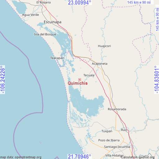
Quimichis GPS coordinates[2]
22° 21' 40.392" North, 105° 32' 20.868" West
| Map corner | latitude | longitude |
|---|---|---|
| Upper-left | 23.00994°, | -106.24226° |
| Center: | 22.36122°, | -105.53913° |
| Lower-right: | 21.70946°, | -104.83601° |
| Map W x H: | 144.6×144.6 km | = 89.9×89.9mi |
| max Lat: | 32.7° ⇑14% North |
| Quimichis: | 22.36122° |
| min Lat: | ⇓86% South 14.53588° |
| min Long | Quimichis | max Long |
| -117.105° | -105.53913° | -86.73105° |
| W 6.6%⇐ | ⇒93.4% E |
Elevation
Elevation of Quimichis is 8 m = 26 ft, and this is 1245.7 m = 4087 ft below average elevation for this country.
| Max E: |
3497 m = 11473 ft | 98.1% |
| Avg. | 1253.7 m = 4113 ft | |
| Quimichis | 8 m = 26 ft | |
Min E: |
-1 m = -3 ft | 1.9% |
See also: Mexico elevation on elevation.city.
Geographical zone
Quimichis is located in North Torrid zone (between Equator and Tropic of Cancer). Distance of this Northern Tropic circle is 119.6 km =74.3 mi to North.| Distance of | km | miles | from Quimichis |
|---|---|---|---|
| North Pole | 7520.7 | 4673.1 | to North |
| Arctic Circle | 4914.8 | 3053.9 | to North |
| Tropic Cancer | 119.6 | 74.3 | to North |
| Equator | 2486.3 | 1544.9 | to South |


Nearby cities:
15 places around Quimichis: (largest is in red/bold)
• Atotonilco
6.5 km =4 mi,  62°
62°
• Camalotita
12.1 km =7.5 mi,  66°
66°
• El Aguaje
16 km =9.9 mi,  8°
8°
• El Arrayán
13.6 km =8.5 mi,  103°
103°
• El Filo
8.5 km =5.3 mi,  75°
75°
• El Limón
11.4 km =7.1 mi,  123°
123°
• La Guásima
16.4 km =10.2 mi, 72°
• La Presa
15.1 km =9.4 mi, 97°
• Milpas Viejas
6.6 km =4.1 mi,  86°
86°
• Novillero
12.9 km =8 mi,  279°
279°
• Pajaritos
10.7 km =6.6 mi, 5°
• Paso Hondo
4.5 km =2.8 mi,  330°
330°
• Río Viejo
3.6 km =2.2 mi, 5°
• San Felipe Aztatán
12.5 km =7.8 mi, 78°
• Tecuala
9.3 km =5.8 mi, 63°
Sources, notices
• [Note1] Compared only with cities in Mexico existing in our database
• [Src1] Map data: © OpenStreetMap contributors (CC-BY-SA)
• [Src2] Other city data from geonames.org with taken over terms of usage.
• [Src3] Geographical zone / Annual Mean Temperature by Robert A. Rohde @ Wikipedia
