La Guásima geodata
La Guásima (Nayarit) is a populated place; located in Mexico in America/Mazatlan (GMT-7) time zone. With population of 1,040 people, there are 8386 cities with bigger population in this country. Compared to other cities in Mexico, 86.3% of cities are located further ↓South; 93% of cities are located further →East and 92.1% of cities have higher elevation than La Guásima. Note1


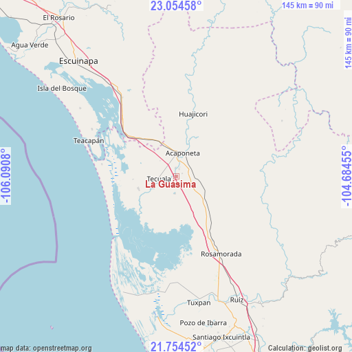
La Guásima GPS coordinates[2]
22° 24' 21.852" North, 105° 23' 15.612" West
| Map corner | latitude | longitude |
|---|---|---|
| Upper-left | 23.05458°, | -106.0908° |
| Center: | 22.40607°, | -105.38767° |
| Lower-right: | 21.75452°, | -104.68455° |
| Map W x H: | 144.6×144.6 km | = 89.9×89.9mi |
| max Lat: | 32.7° ⇑13.7% North |
| La Guásima: | 22.40607° |
| min Lat: | ⇓86.3% South 14.53588° |
| min Long | La Guásima | max Long |
| -117.105° | -105.38767° | -86.73105° |
| W 7%⇐ | ⇒93% E |
Elevation
Elevation of La Guásima is 19 m = 62 ft, and this is 1234.7 m = 4051 ft below average elevation for this country.
| Max E: |
3497 m = 11473 ft | 92.1% |
| Avg. | 1253.7 m = 4113 ft | |
| La Guásima | 19 m = 62 ft | |
Min E: |
-1 m = -3 ft | 7.9% |
See also: Mexico elevation on elevation.city.
Geographical zone
La Guásima is located in North Torrid zone (between Equator and Tropic of Cancer). Distance of this Northern Tropic circle is 114.6 km =71.2 mi to North.| Distance of | km | miles | from La Guásima |
|---|---|---|---|
| North Pole | 7515.7 | 4670 | to North |
| Arctic Circle | 4909.9 | 3050.9 | to North |
| Tropic Cancer | 114.6 | 71.2 | to North |
| Equator | 2491.3 | 1548 | to South |


Nearby cities:
15 places around La Guásima: (largest is in red/bold)
• Acaponeta
10.1 km =6.3 mi,  14°
14°
• Atotonilco
10 km =6.2 mi,  258°
258°
• Camalotita
4.5 km =2.8 mi,  267°
267°
• El Arrayán
8.5 km =5.3 mi,  195°
195°
• El Centenario
12 km =7.5 mi, 11°
• El Filo
7.9 km =4.9 mi,  248°
248°
• El Limón
12.8 km =8 mi,  208°
208°
• El Resbalón
8.9 km =5.5 mi,  98°
98°
• La Presa
7 km =4.3 mi,  184°
184°
• Llano de la Cruz
3.4 km =2.1 mi,  19°
19°
• Milpas Viejas
10.1 km =6.3 mi,  243°
243°
• San Felipe Aztatán
4.1 km =2.5 mi,  233°
233°
• San José de Gracia
8.4 km =5.2 mi, 6°
• Sayulilla
3.6 km =2.2 mi,  353°
353°
• Tecuala
7.3 km =4.5 mi, 263°
Sources, notices
• [Note1] Compared only with cities in Mexico existing in our database
• [Src1] Map data: © OpenStreetMap contributors (CC-BY-SA)
• [Src2] Other city data from geonames.org with taken over terms of usage.
• [Src3] Geographical zone / Annual Mean Temperature by Robert A. Rohde @ Wikipedia
