Potam geodata
Potam (Sonora) is a populated place; located in Mexico in America/Hermosillo (GMT-7) time zone. With population of 6,417 people, there are 1456 cities with bigger population in this country. Compared to other cities in Mexico, 97% of cities are located further ↓South; 98.4% of cities are located further →East and 97% of cities have higher elevation than Potam. Note1


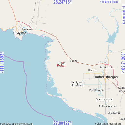
Potam GPS coordinates[2]
27° 37' 33.6" North, 110° 24' 56.88" West
| Map corner | latitude | longitude |
|---|---|---|
| Upper-left | 28.24718°, | -111.11893° |
| Center: | 27.626°, | -110.4158° |
| Lower-right: | 27.00127°, | -109.71268° |
| Map W x H: | 138.5×138.5 km | = 86.1×86.1mi |
| max Lat: | 32.7° ⇑3% North |
| Potam: | 27.626° |
| min Lat: | ⇓97% South 14.53588° |
| min Long | Potam | max Long |
| -117.105° | -110.4158° | -86.73105° |
| W 1.6%⇐ | ⇒98.4% E |
Elevation
Elevation of Potam is 10 m = 33 ft, and this is 1243.7 m = 4080 ft below average elevation for this country.
| Max E: |
3497 m = 11473 ft | 97% |
| Avg. | 1253.7 m = 4113 ft | |
| Potam | 10 m = 33 ft | |
Min E: |
-1 m = -3 ft | 3% |
See also: Mexico elevation on elevation.city.
Geographical zone
Potam is located in North temperate zone (between Tropic of Cancer and the Arctic Circle). Distance of this Northern Tropic circle is 465.8 km =289.4 mi to South.| Distance of | km | miles | from Potam |
|---|---|---|---|
| North Pole | 6935.3 | 4309.4 | to North |
| Arctic Circle | 4329.5 | 2690.2 | to North |
| Tropic Cancer | 465.8 | 289.4 | to South |
| Equator | 3071.7 | 1908.7 | to South |


Nearby cities:
15 places around Potam: (largest is in red/bold)
• Bahía de Lobos
30.7 km =19.1 mi,  187°
187°
• Bataconcica
29.1 km =18.1 mi,  105°
105°
• Bácum
33.8 km =21 mi,  104°
104°
• Campo Sesenta
36.8 km =22.9 mi,  122°
122°
• Francisco Javier Mina
35.3 km =21.9 mi, 121°
• Guásimas (De Belem)
33.2 km =20.6 mi,  330°
330°
• Loma de Bácum
32.8 km =20.4 mi, 97°
• Loma de Guamúchil
42.2 km =26.2 mi,  92°
92°
• Mora Villalobos
37.7 km =23.4 mi, 109°
• Primero de Mayo
39.2 km =24.4 mi,  132°
132°
• San Ignacio Río Muerto
28.7 km =17.8 mi,  144°
144°
• San José de Bacum
29.6 km =18.4 mi, 114°
• Santa Teresa
39.9 km =24.8 mi, 102°
• Vicam
12.2 km =7.6 mi,  80°
80°
• Vícam Pueblo
10.3 km =6.4 mi, 115°
Sources, notices
• [Note1] Compared only with cities in Mexico existing in our database
• [Src1] Map data: © OpenStreetMap contributors (CC-BY-SA)
• [Src2] Other city data from geonames.org with taken over terms of usage.
• [Src3] Geographical zone / Annual Mean Temperature by Robert A. Rohde @ Wikipedia
