Paso del Aguila geodata
Paso del Aguila (Coahuila) is a populated place; located in Mexico in America/Monterrey (GMT-6) time zone. With population of 800 people, there are 10908 cities with bigger population in this country. Compared to other cities in Mexico, 93.2% of cities are located further ↓South; 87.6% of cities are located further →East and 57% of cities have higher elevation than Paso del Aguila. Note1


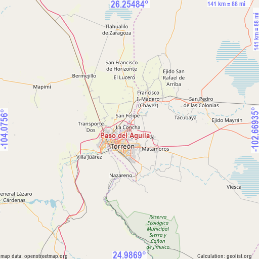
Paso del Aguila GPS coordinates[2]
25° 37' 21.18" North, 103° 22' 20.892" West
| Map corner | latitude | longitude |
|---|---|---|
| Upper-left | 26.25484°, | -104.0756° |
| Center: | 25.62255°, | -103.37247° |
| Lower-right: | 24.9869°, | -102.66935° |
| Map W x H: | 141×141 km | = 87.6×87.6mi |
| max Lat: | 32.7° ⇑6.8% North |
| Paso del Aguila: | 25.62255° |
| min Lat: | ⇓93.2% South 14.53588° |
| min Long | Paso del Aguila | max Long |
| -117.105° | -103.37247° | -86.73105° |
| W 12.4%⇐ | ⇒87.6% E |
Elevation
Elevation of Paso del Aguila is 1122 m = 3681 ft, and this is 131.7 m = 432 ft below average elevation for this country.
| Max E: |
3497 m = 11473 ft | 57% |
| Avg. | 1253.7 m = 4113 ft | |
| Paso del Aguila | 1122 m = 3681 ft | |
Min E: |
-1 m = -3 ft | 43% |
See also: Mexico elevation on elevation.city.
Geographical zone
Paso del Aguila is located in North temperate zone (between Tropic of Cancer and the Arctic Circle). Distance of this Northern Tropic circle is 243 km =151 mi to South.| Distance of | km | miles | from Paso del Aguila |
|---|---|---|---|
| North Pole | 7158.1 | 4447.8 | to North |
| Arctic Circle | 4552.2 | 2828.6 | to North |
| Tropic Cancer | 243 | 151 | to South |
| Equator | 2849 | 1770.3 | to South |


Nearby cities:
15 places around Paso del Aguila: (largest is in red/bold)
• Albia
4.9 km =3 mi,  11°
11°
• El Cambio
5 km =3.1 mi,  66°
66°
• El Cariño
7.1 km =4.4 mi,  278°
278°
• El Castillo
7.1 km =4.4 mi,  312°
312°
• El Perú
3.6 km =2.2 mi,  127°
127°
• Escuadrón Doscientos Uno
6.2 km =3.9 mi,  22°
22°
• Estación Viñedo
5.9 km =3.7 mi,  317°
317°
• La Concha
1.7 km =1.1 mi,  327°
327°
• La Flor
6.6 km =4.1 mi,  3°
3°
• La Palma
5.3 km =3.3 mi,  107°
107°
• La Paz
3.5 km =2.2 mi,  156°
156°
• Maravillas
5.1 km =3.2 mi,  38°
38°
• Monte Alegre
6.5 km =4 mi,  93°
93°
• Ricardo Flores Magón
1.9 km =1.2 mi, 87°
• San José de Viñedo
4.2 km =2.6 mi, 313°
Sources, notices
• [Note1] Compared only with cities in Mexico existing in our database
• [Src1] Map data: © OpenStreetMap contributors (CC-BY-SA)
• [Src2] Other city data from geonames.org with taken over terms of usage.
• [Src3] Geographical zone / Annual Mean Temperature by Robert A. Rohde @ Wikipedia
