El Castillo geodata
El Castillo (Durango) is a populated place; located in Mexico in America/Monterrey (GMT-6) time zone. With population of 580 people, there are 14779 cities with bigger population in this country. Compared to other cities in Mexico, 93.5% of cities are located further ↓South; 87.9% of cities are located further →East and 57.1% of cities have higher elevation than El Castillo. Note1


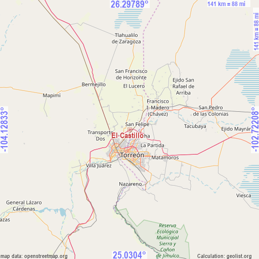
El Castillo GPS coordinates[2]
25° 39' 56.988" North, 103° 25' 30.72" West
| Map corner | latitude | longitude |
|---|---|---|
| Upper-left | 26.29789°, | -104.12833° |
| Center: | 25.66583°, | -103.4252° |
| Lower-right: | 25.0304°, | -102.72208° |
| Map W x H: | 140.9×140.9 km | = 87.6×87.6mi |
| max Lat: | 32.7° ⇑6.5% North |
| El Castillo: | 25.66583° |
| min Lat: | ⇓93.5% South 14.53588° |
| min Long | El Castillo | max Long |
| -117.105° | -103.4252° | -86.73105° |
| W 12.1%⇐ | ⇒87.9% E |
Elevation
Elevation of El Castillo is 1119 m = 3671 ft, and this is 134.7 m = 442 ft below average elevation for this country.
| Max E: |
3497 m = 11473 ft | 57.1% |
| Avg. | 1253.7 m = 4113 ft | |
| El Castillo | 1119 m = 3671 ft | |
Min E: |
-1 m = -3 ft | 42.9% |
See also: Mexico elevation on elevation.city.
Geographical zone
El Castillo is located in North temperate zone (between Tropic of Cancer and the Arctic Circle). Distance of this Northern Tropic circle is 247.9 km =154 mi to South.| Distance of | km | miles | from El Castillo |
|---|---|---|---|
| North Pole | 7153.3 | 4444.9 | to North |
| Arctic Circle | 4547.4 | 2825.6 | to North |
| Tropic Cancer | 247.9 | 154 | to South |
| Equator | 2853.8 | 1773.3 | to South |


Nearby cities:
15 places around El Castillo: (largest is in red/bold)
• Albia
6.3 km =3.9 mi,  90°
90°
• El Cariño
4.1 km =2.5 mi,  205°
205°
• El Quemado
6.8 km =4.2 mi,  42°
42°
• El Vergelito
5.9 km =3.7 mi,  347°
347°
• Escuadrón Doscientos Uno
7.8 km =4.8 mi,  83°
83°
• Estación Viñedo
1.4 km =0.9 mi,  107°
107°
• La Concha
5.6 km =3.5 mi,  127°
127°
• La Flor
6 km =3.7 mi,  73°
73°
• La Popular
4.4 km =2.7 mi,  290°
290°
• La Tehua
5.2 km =3.2 mi,  358°
358°
• Nazas (Las Lagartijas)
5.2 km =3.2 mi,  220°
220°
• Paso del Aguila
7.1 km =4.4 mi, 132°
• Reforma
7.8 km =4.8 mi, 39°
• San Felipe
5.2 km =3.2 mi,  54°
54°
• San José de Viñedo
3 km =1.9 mi, 130°
Sources, notices
• [Note1] Compared only with cities in Mexico existing in our database
• [Src1] Map data: © OpenStreetMap contributors (CC-BY-SA)
• [Src2] Other city data from geonames.org with taken over terms of usage.
• [Src3] Geographical zone / Annual Mean Temperature by Robert A. Rohde @ Wikipedia
