Pabellón de Hidalgo geodata
Pabellón de Hidalgo (Aguascalientes) is a populated place; located in Mexico in America/Mexico_City (GMT-6) time zone. With population of 4,316 people, there are 2125 cities with bigger population in this country. Compared to other cities in Mexico, 85.1% of cities are located further ↓South; 83.2% of cities are located further →East and 70.5% of cities have lower elevation than Pabellón de Hidalgo. Note1


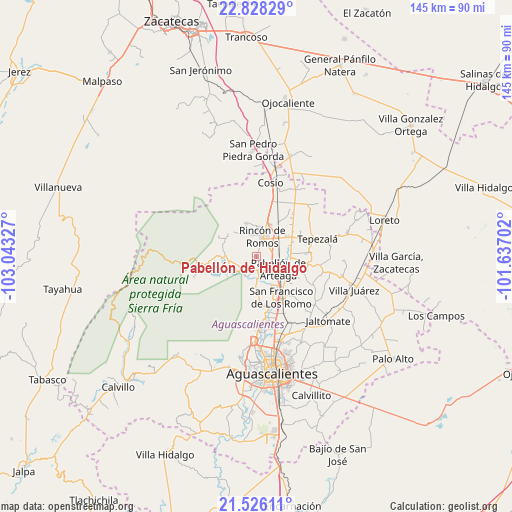
Pabellón de Hidalgo GPS coordinates[2]
22° 10' 43.356" North, 102° 20' 24.504" West
| Map corner | latitude | longitude |
|---|---|---|
| Upper-left | 22.82829°, | -103.04327° |
| Center: | 22.17871°, | -102.34014° |
| Lower-right: | 21.52611°, | -101.63702° |
| Map W x H: | 144.8×144.8 km | = 90×90mi |
| max Lat: | 32.7° ⇑14.9% North |
| Pabellón de Hidalgo: | 22.17871° |
| min Lat: | ⇓85.1% South 14.53588° |
| min Long | Pabellón de Hi | max Long |
| -117.105° | -102.34014° | -86.73105° |
| W 16.8%⇐ | ⇒83.2% E |
Elevation
Elevation of Pabellón de Hidalgo is 1934 m = 6345 ft, and this is 680.3 m = 2232 ft above average elevation for this country.
| Max E: |
3497 m = 11473 ft | 29.5% |
| Pabellón de Hidalgo | 1934 m 6345 ft | |
| Avg. | 1253.7 m = 4113 ft | |
Min E: |
-1 m = -3 ft | 70.5% |
See also: Mexico elevation on elevation.city.
Geographical zone
Pabellón de Hidalgo is located in North Torrid zone (between Equator and Tropic of Cancer). Distance of this Northern Tropic circle is 139.9 km =86.9 mi to North.| Distance of | km | miles | from Pabellón de Hidalgo |
|---|---|---|---|
| North Pole | 7541 | 4685.8 | to North |
| Arctic Circle | 4935.1 | 3066.5 | to North |
| Tropic Cancer | 139.9 | 86.9 | to North |
| Equator | 2466 | 1532.3 | to South |


Nearby cities:
15 places around Pabellón de Hidalgo: (largest is in red/bold)
• Carboneras
9.7 km =6 mi,  87°
87°
• El Bajío
8.1 km =5 mi,  23°
23°
• El Gigante
9.9 km =6.2 mi,  70°
70°
• El Saucillo
9.9 km =6.2 mi,  25°
25°
• Emiliano Zapata
9 km =5.6 mi,  153°
153°
• Escaleras
8 km =5 mi,  4°
4°
• Estancia de Mosqueira
4.3 km =2.7 mi,  197°
197°
• Fresnillo
7.4 km =4.6 mi, 1°
• La Boquilla
9.4 km =5.8 mi,  341°
341°
• Morelos
6.6 km =4.1 mi,  345°
345°
• Pabellón de Arteaga
7.4 km =4.6 mi,  118°
118°
• Rincón de Romos
5.8 km =3.6 mi, 18°
• San José de Gracia
8.4 km =5.2 mi,  246°
246°
• San Luis de Letras
6.5 km =4 mi,  137°
137°
• Santiago
6.6 km =4.1 mi,  177°
177°
Sources, notices
• [Note1] Compared only with cities in Mexico existing in our database
• [Src1] Map data: © OpenStreetMap contributors (CC-BY-SA)
• [Src2] Other city data from geonames.org with taken over terms of usage.
• [Src3] Geographical zone / Annual Mean Temperature by Robert A. Rohde @ Wikipedia
