El Gigante geodata
El Gigante (Aguascalientes) is a populated place; located in Mexico in America/Mexico_City (GMT-6) time zone. With population of 664 people, there are 13077 cities with bigger population in this country. Compared to other cities in Mexico, 85.2% of cities are located further ↓South; 82.4% of cities are located further →East and 69.2% of cities have lower elevation than El Gigante. Note1


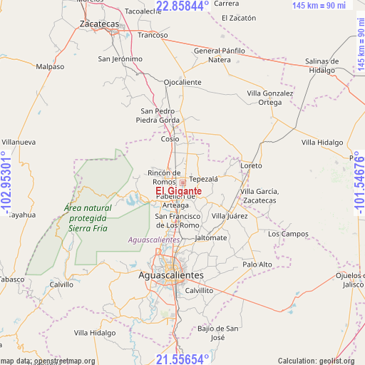
El Gigante GPS coordinates[2]
22° 12' 32.4" North, 102° 14' 59.568" West
| Map corner | latitude | longitude |
|---|---|---|
| Upper-left | 22.85844°, | -102.95301° |
| Center: | 22.209°, | -102.24988° |
| Lower-right: | 21.55654°, | -101.54676° |
| Map W x H: | 144.8×144.8 km | = 90×90mi |
| max Lat: | 32.7° ⇑14.8% North |
| El Gigante: | 22.209° |
| min Lat: | ⇓85.2% South 14.53588° |
| min Long | El Gigante | max Long |
| -117.105° | -102.24988° | -86.73105° |
| W 17.6%⇐ | ⇒82.4% E |
Elevation
Elevation of El Gigante is 1911 m = 6270 ft, and this is 657.3 m = 2156 ft above average elevation for this country.
| Max E: |
3497 m = 11473 ft | 30.8% |
| El Gigante | 1911 m 6270 ft | |
| Avg. | 1253.7 m = 4113 ft | |
Min E: |
-1 m = -3 ft | 69.2% |
See also: Mexico elevation on elevation.city.
Geographical zone
El Gigante is located in North Torrid zone (between Equator and Tropic of Cancer). Distance of this Northern Tropic circle is 136.5 km =84.8 mi to North.| Distance of | km | miles | from El Gigante |
|---|---|---|---|
| North Pole | 7537.7 | 4683.7 | to North |
| Arctic Circle | 4931.8 | 3064.5 | to North |
| Tropic Cancer | 136.5 | 84.8 | to North |
| Equator | 2469.4 | 1534.4 | to South |


Nearby cities:
15 places around El Gigante: (largest is in red/bold)
• California
8.5 km =5.3 mi,  358°
358°
• Carboneras
2.9 km =1.8 mi,  172°
172°
• El Bajío
7.3 km =4.5 mi,  304°
304°
• El Chayote
8.7 km =5.4 mi,  7°
7°
• El Porvenir
3.9 km =2.4 mi,  23°
23°
• El Refugio
4.8 km =3 mi,  151°
151°
• El Saucillo
7.5 km =4.7 mi,  318°
318°
• La Victoria
1.6 km =1 mi,  58°
58°
• Los Alamitos
5.7 km =3.5 mi,  1°
1°
• Mar Negro
3.7 km =2.3 mi,  338°
338°
• Pabellón de Arteaga
7.5 km =4.7 mi,  201°
201°
• Rincón de Romos
7.7 km =4.8 mi,  286°
286°
• San Antonio
2.1 km =1.3 mi, 358°
• San Luis de Letras
9.5 km =5.9 mi,  210°
210°
• Tepezalá
8.4 km =5.2 mi,  78°
78°
Sources, notices
• [Note1] Compared only with cities in Mexico existing in our database
• [Src1] Map data: © OpenStreetMap contributors (CC-BY-SA)
• [Src2] Other city data from geonames.org with taken over terms of usage.
• [Src3] Geographical zone / Annual Mean Temperature by Robert A. Rohde @ Wikipedia
