Naranjo geodata
Naranjo (Sinaloa) is a populated place; located in Mexico in America/Mazatlan (GMT-7) time zone. With population of 6,307 people, there are 1474 cities with bigger population in this country. Compared to other cities in Mexico, 94.3% of cities are located further ↓South; 96.3% of cities are located further →East and 83.6% of cities have higher elevation than Naranjo. Note1


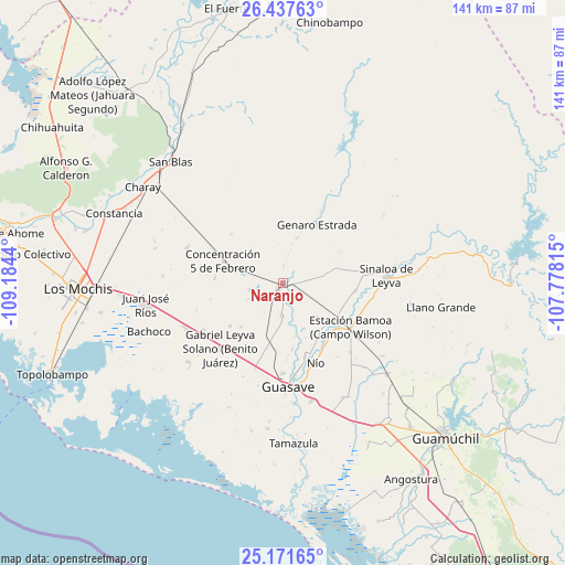
Naranjo GPS coordinates[2]
25° 48' 22.788" North, 108° 28' 52.572" West
| Map corner | latitude | longitude |
|---|---|---|
| Upper-left | 26.43763°, | -109.1844° |
| Center: | 25.80633°, | -108.48127° |
| Lower-right: | 25.17165°, | -107.77815° |
| Map W x H: | 140.8×140.8 km | = 87.5×87.5mi |
| max Lat: | 32.7° ⇑5.7% North |
| Naranjo: | 25.80633° |
| min Lat: | ⇓94.3% South 14.53588° |
| min Long | Naranjo | max Long |
| -117.105° | -108.48127° | -86.73105° |
| W 3.7%⇐ | ⇒96.3% E |
Elevation
Elevation of Naranjo is 54 m = 177 ft, and this is 1199.7 m = 3936 ft below average elevation for this country.
| Max E: |
3497 m = 11473 ft | 83.6% |
| Avg. | 1253.7 m = 4113 ft | |
| Naranjo | 54 m = 177 ft | |
Min E: |
-1 m = -3 ft | 16.4% |
See also: Mexico elevation on elevation.city.
Geographical zone
Naranjo is located in North temperate zone (between Tropic of Cancer and the Arctic Circle). Distance of this Northern Tropic circle is 263.5 km =163.7 mi to South.| Distance of | km | miles | from Naranjo |
|---|---|---|---|
| North Pole | 7137.7 | 4435.2 | to North |
| Arctic Circle | 4531.8 | 2815.9 | to North |
| Tropic Cancer | 263.5 | 163.7 | to South |
| Equator | 2869.4 | 1783 | to South |


Nearby cities:
15 places around Naranjo: (largest is in red/bold)
• Alfonso G. Calderón Velarde
12.3 km =7.6 mi,  259°
259°
• Carboneras
15.1 km =9.4 mi,  134°
134°
• Concentración 5 de Febrero
15.8 km =9.8 mi,  290°
290°
• Ejido Abelardo L. Rodríguez
10.3 km =6.4 mi,  206°
206°
• Ejido Playa Segunda
5.2 km =3.2 mi,  87°
87°
• El Alamito
4.3 km =2.7 mi,  2°
2°
• El Sabino
16.3 km =10.1 mi,  147°
147°
• El Zopilote
14.7 km =9.1 mi,  115°
115°
• Gabriel Leyva Velázquez
8.4 km =5.2 mi, 258°
• La Noria
10.9 km =6.8 mi,  185°
185°
• La Presita
15.2 km =9.4 mi,  223°
223°
• La Trinidad
8.1 km =5 mi,  182°
182°
• Las Juntas de Chamicari
14.9 km =9.3 mi,  157°
157°
• Las Quemazones
13.7 km =8.5 mi,  167°
167°
• Portugués de Gálvez
12.2 km =7.6 mi,  135°
135°
Sources, notices
• [Note1] Compared only with cities in Mexico existing in our database
• [Src1] Map data: © OpenStreetMap contributors (CC-BY-SA)
• [Src2] Other city data from geonames.org with taken over terms of usage.
• [Src3] Geographical zone / Annual Mean Temperature by Robert A. Rohde @ Wikipedia
