Matatán geodata
Matatán (Sinaloa) is a populated place; located in Mexico in America/Mazatlan (GMT-7) time zone. With population of 612 people, there are 14088 cities with bigger population in this country. Compared to other cities in Mexico, 88.1% of cities are located further ↓South; 93.5% of cities are located further →East and 83.3% of cities have higher elevation than Matatán. Note1


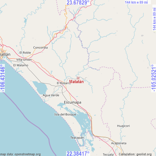
Matatán GPS coordinates[2]
23° 1' 58.008" North, 105° 43' 41.988" West
| Map corner | latitude | longitude |
|---|---|---|
| Upper-left | 23.67829°, | -106.43146° |
| Center: | 23.03278°, | -105.72833° |
| Lower-right: | 22.38417°, | -105.02521° |
| Map W x H: | 143.9×143.9 km | = 89.4×89.4mi |
| max Lat: | 32.7° ⇑11.9% North |
| Matatán: | 23.03278° |
| min Lat: | ⇓88.1% South 14.53588° |
| min Long | Matatán | max Long |
| -117.105° | -105.72833° | -86.73105° |
| W 6.5%⇐ | ⇒93.5% E |
Elevation
Elevation of Matatán is 58 m = 190 ft, and this is 1195.7 m = 3923 ft below average elevation for this country.
| Max E: |
3497 m = 11473 ft | 83.3% |
| Avg. | 1253.7 m = 4113 ft | |
| Matatán | 58 m = 190 ft | |
Min E: |
-1 m = -3 ft | 16.7% |
See also: Mexico elevation on elevation.city.
Geographical zone
Matatán is located in North Torrid zone (between Equator and Tropic of Cancer). Distance of this Northern Tropic circle is 44.9 km =27.9 mi to North.| Distance of | km | miles | from Matatán |
|---|---|---|---|
| North Pole | 7446.1 | 4626.8 | to North |
| Arctic Circle | 4840.2 | 3007.6 | to North |
| Tropic Cancer | 44.9 | 27.9 | to North |
| Equator | 2561 | 1591.3 | to South |


Nearby cities:
15 places around Matatán: (largest is in red/bold)
• Agua Verde
29.6 km =18.4 mi,  238°
238°
• Apoderado
24.4 km =15.2 mi, 235°
• Cacalotán
12.3 km =7.6 mi,  288°
288°
• Chametla
29.1 km =18.1 mi,  233°
233°
• Chele
25.5 km =15.8 mi,  318°
318°
• Chilillos
12.2 km =7.6 mi,  250°
250°
• Ejido Cajón Ojo de Agua Número Dos
28.9 km =18 mi, 239°
• El Ejido Tablón Número Uno (Las Cruces Cuatas)
26.9 km =16.7 mi,  280°
280°
• El Matadero
33 km =20.5 mi,  263°
263°
• El Pozole
23 km =14.3 mi, 235°
• El Rosario
13.9 km =8.6 mi, 251°
• Escuinapa
22.8 km =14.2 mi,  192°
192°
• Las Higueras
23.4 km =14.5 mi, 275°
• Potrerillos
22.2 km =13.8 mi,  268°
268°
• Tecualilla
30.2 km =18.8 mi,  168°
168°
Sources, notices
• [Note1] Compared only with cities in Mexico existing in our database
• [Src1] Map data: © OpenStreetMap contributors (CC-BY-SA)
• [Src2] Other city data from geonames.org with taken over terms of usage.
• [Src3] Geographical zone / Annual Mean Temperature by Robert A. Rohde @ Wikipedia
