Los Mochis geodata
Los Mochis (Sinaloa) is a seat of a second-order administrative division; located in Mexico in America/Mazatlan (GMT-7) time zone. With population of 256,613 people, there are 73 cities with bigger population in this country. Compared to other cities in Mexico, 94.2% of cities are located further ↓South; 97% of cities are located further →East and 94.6% of cities have higher elevation than Los Mochis. Note1


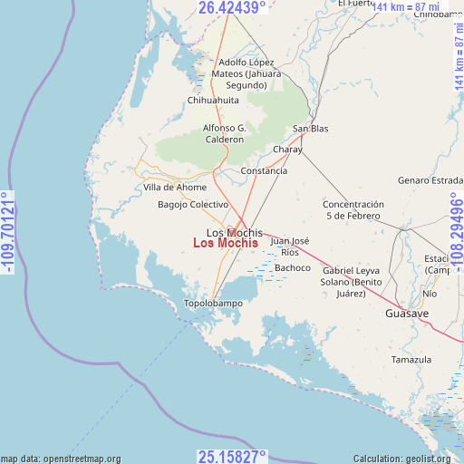
Los Mochis GPS coordinates[2]
25° 47' 34.872" North, 108° 59' 53.088" West
| Map corner | latitude | longitude |
|---|---|---|
| Upper-left | 26.42439°, | -109.70121° |
| Center: | 25.79302°, | -108.99808° |
| Lower-right: | 25.15827°, | -108.29496° |
| Map W x H: | 140.8×140.8 km | = 87.5×87.5mi |
| max Lat: | 32.7° ⇑5.8% North |
| Los Mochis: | 25.79302° |
| min Lat: | ⇓94.2% South 14.53588° |
| min Long | Los Mochis | max Long |
| -117.105° | -108.99808° | -86.73105° |
| W 3%⇐ | ⇒97% E |
Elevation
Elevation of Los Mochis is 14 m = 46 ft, and this is 1239.7 m = 4067 ft below average elevation for this country.
| Max E: |
3497 m = 11473 ft | 94.6% |
| Avg. | 1253.7 m = 4113 ft | |
| Los Mochis | 14 m = 46 ft | |
Min E: |
-1 m = -3 ft | 5.4% |
See also: Los Mochis elevation on elevation.city.
Geographical zone
Los Mochis is located in North temperate zone (between Tropic of Cancer and the Arctic Circle). Distance of this Northern Tropic circle is 262 km =162.8 mi to South.| Distance of | km | miles | from Los Mochis |
|---|---|---|---|
| North Pole | 7139.1 | 4436 | to North |
| Arctic Circle | 4533.3 | 2816.9 | to North |
| Tropic Cancer | 262 | 162.8 | to South |
| Equator | 2867.9 | 1782 | to South |


Nearby cities:
15 places around Los Mochis: (largest is in red/bold)
• Benito Juárez
4.1 km =2.5 mi,  238°
238°
• Campo la Arrocera
9.9 km =6.2 mi,  54°
54°
• Ejido Cinco de Mayo
7.5 km =4.7 mi,  31°
31°
• Ejido Ohuira
8.7 km =5.4 mi,  167°
167°
• Felipe Angeles
9.3 km =5.8 mi,  332°
332°
• Flor Azul
8.6 km =5.3 mi,  353°
353°
• Gabriel Leyva Solano (Zapotillo Dos)
10.1 km =6.3 mi, 353°
• Goros Número Dos
10.4 km =6.5 mi, 333°
• Las Compuertas
5.9 km =3.7 mi,  338°
338°
• Luisiana
6.7 km =4.2 mi,  279°
279°
• Mochis
6.5 km =4 mi,  305°
305°
• Plan de Ayala (Campo Cinco)
5.1 km =3.2 mi, 238°
• Plan de San Luis
6.8 km =4.2 mi,  250°
250°
• Primero de Mayo
8.7 km =5.4 mi,  133°
133°
• Ricardo Flores Magón
5.8 km =3.6 mi,  177°
177°
Sources, notices
• [Note1] Compared only with cities in Mexico existing in our database
• [Src1] Map data: © OpenStreetMap contributors (CC-BY-SA)
• [Src2] Other city data from geonames.org with taken over terms of usage.
• [Src3] Geographical zone / Annual Mean Temperature by Robert A. Rohde @ Wikipedia
