Mochis geodata
Mochis (Sinaloa) is a populated place; located in Mexico in America/Mazatlan (GMT-7) time zone. With population of 2,924 people, there are 3047 cities with bigger population in this country. Compared to other cities in Mexico, 94.5% of cities are located further ↓South; 97.1% of cities are located further →East and 97% of cities have higher elevation than Mochis. Note1


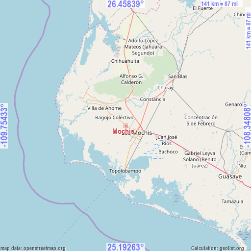
Mochis GPS coordinates[2]
25° 49' 37.92" North, 109° 3' 4.32" West
| Map corner | latitude | longitude |
|---|---|---|
| Upper-left | 26.45839°, | -109.75433° |
| Center: | 25.8272°, | -109.0512° |
| Lower-right: | 25.19263°, | -108.34808° |
| Map W x H: | 140.7×140.7 km | = 87.4×87.4mi |
| max Lat: | 32.7° ⇑5.5% North |
| Mochis: | 25.8272° |
| min Lat: | ⇓94.5% South 14.53588° |
| min Long | Mochis | max Long |
| -117.105° | -109.0512° | -86.73105° |
| W 2.9%⇐ | ⇒97.1% E |
Elevation
Elevation of Mochis is 10 m = 33 ft, and this is 1243.7 m = 4080 ft below average elevation for this country.
| Max E: |
3497 m = 11473 ft | 97% |
| Avg. | 1253.7 m = 4113 ft | |
| Mochis | 10 m = 33 ft | |
Min E: |
-1 m = -3 ft | 3% |
See also: Mexico elevation on elevation.city.
Geographical zone
Mochis is located in North temperate zone (between Tropic of Cancer and the Arctic Circle). Distance of this Northern Tropic circle is 265.8 km =165.2 mi to South.| Distance of | km | miles | from Mochis |
|---|---|---|---|
| North Pole | 7135.3 | 4433.7 | to North |
| Arctic Circle | 4529.5 | 2814.5 | to North |
| Tropic Cancer | 265.8 | 165.2 | to South |
| Equator | 2871.7 | 1784.4 | to South |


Nearby cities:
15 places around Mochis: (largest is in red/bold)
• Agua Nueva
7.7 km =4.8 mi,  326°
326°
• Benito Juárez
6.2 km =3.9 mi,  163°
163°
• CERESO Nuevo
7.2 km =4.5 mi,  7°
7°
• Cuchilla de Cachoana
8.2 km =5.1 mi,  313°
313°
• Ejido Dieciocho de Marzo
4.9 km =3 mi,  317°
317°
• Felipe Angeles
4.6 km =2.9 mi, 13°
• Flor Azul
6.4 km =4 mi,  42°
42°
• Gabriel Leyva Solano (Zapotillo Dos)
7.5 km =4.7 mi,  34°
34°
• Goros Número Dos
5.6 km =3.5 mi, 7°
• Las Compuertas
3.5 km =2.2 mi,  62°
62°
• Los Mochis
6.5 km =4 mi,  125°
125°
• Luisiana
3 km =1.9 mi,  205°
205°
• Plan de Ayala (Campo Cinco)
6.5 km =4 mi,  171°
171°
• Plan de San Luis
6.2 km =3.9 mi,  190°
190°
• Vallejo (Porvenir Vallejo)
6.6 km =4.1 mi,  340°
340°
Sources, notices
• [Note1] Compared only with cities in Mexico existing in our database
• [Src1] Map data: © OpenStreetMap contributors (CC-BY-SA)
• [Src2] Other city data from geonames.org with taken over terms of usage.
• [Src3] Geographical zone / Annual Mean Temperature by Robert A. Rohde @ Wikipedia
