Purísima geodata
Purísima (Coahuila) is a populated place; located in Mexico in America/Monterrey (GMT-6) time zone. With population of 1,771 people, there are 4902 cities with bigger population in this country. Compared to other cities in Mexico, 93.6% of cities are located further ↓South; 87.2% of cities are located further →East and 57.2% of cities have higher elevation than Purísima. Note1


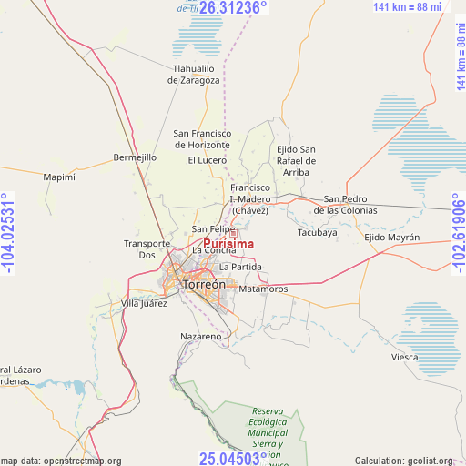
Purísima GPS coordinates[2]
25° 40' 49.368" North, 103° 19' 19.848" West
| Map corner | latitude | longitude |
|---|---|---|
| Upper-left | 26.31236°, | -104.02531° |
| Center: | 25.68038°, | -103.32218° |
| Lower-right: | 25.04503°, | -102.61906° |
| Map W x H: | 140.9×140.9 km | = 87.6×87.6mi |
| max Lat: | 32.7° ⇑6.4% North |
| Purísima: | 25.68038° |
| min Lat: | ⇓93.6% South 14.53588° |
| min Long | Purísima | max Long |
| -117.105° | -103.32218° | -86.73105° |
| W 12.8%⇐ | ⇒87.2% E |
Elevation
Elevation of Purísima is 1118 m = 3668 ft, and this is 135.7 m = 445 ft below average elevation for this country.
| Max E: |
3497 m = 11473 ft | 57.2% |
| Avg. | 1253.7 m = 4113 ft | |
| Purísima | 1118 m = 3668 ft | |
Min E: |
-1 m = -3 ft | 42.8% |
See also: Mexico elevation on elevation.city.
Geographical zone
Purísima is located in North temperate zone (between Tropic of Cancer and the Arctic Circle). Distance of this Northern Tropic circle is 249.5 km =155 mi to South.| Distance of | km | miles | from Purísima |
|---|---|---|---|
| North Pole | 7151.7 | 4443.9 | to North |
| Arctic Circle | 4545.8 | 2824.6 | to North |
| Tropic Cancer | 249.5 | 155 | to South |
| Equator | 2855.4 | 1774.3 | to South |


Nearby cities:
15 places around Purísima: (largest is in red/bold)
• Alamito
5.1 km =3.2 mi,  20°
20°
• Albia
4.4 km =2.7 mi,  247°
247°
• Coyote
4.1 km =2.5 mi,  66°
66°
• El Cambio
4.5 km =2.8 mi,  186°
186°
• El Cuije
2.6 km =1.6 mi,  313°
313°
• El Pilar
5.1 km =3.2 mi,  325°
325°
• Escuadrón Doscientos Uno
2.7 km =1.7 mi,  255°
255°
• Hormiguero
1.9 km =1.2 mi,  281°
281°
• La Flor
4.6 km =2.9 mi,  271°
271°
• Maravillas
3 km =1.9 mi,  217°
217°
• Nuevo León
5.1 km =3.2 mi,  32°
32°
• San Antonio del Coyote
4 km =2.5 mi, 66°
• Santa Ana del Pilar
3.5 km =2.2 mi, 23°
• Solima
5.1 km =3.2 mi,  113°
113°
• Veinte de Noviembre
3.6 km =2.2 mi,  348°
348°
Sources, notices
• [Note1] Compared only with cities in Mexico existing in our database
• [Src1] Map data: © OpenStreetMap contributors (CC-BY-SA)
• [Src2] Other city data from geonames.org with taken over terms of usage.
• [Src3] Geographical zone / Annual Mean Temperature by Robert A. Rohde @ Wikipedia
