El Cuije geodata
El Cuije (Coahuila) is a populated place; located in Mexico in America/Monterrey (GMT-6) time zone. With population of 1,015 people, there are 8582 cities with bigger population in this country. Compared to other cities in Mexico, 93.6% of cities are located further ↓South; 87.4% of cities are located further →East and 57.1% of cities have higher elevation than El Cuije. Note1


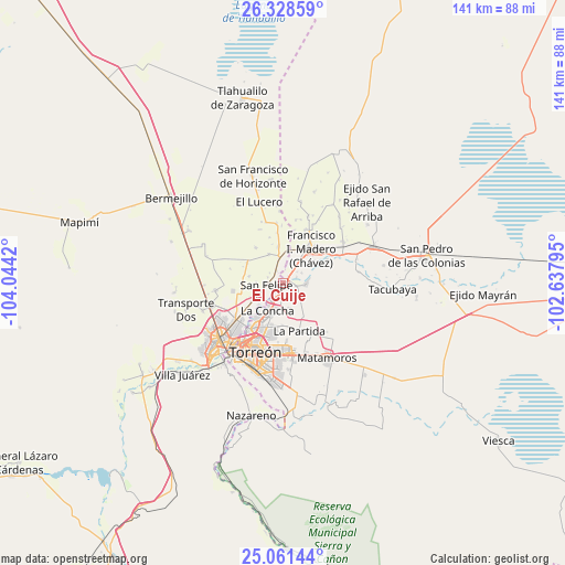
El Cuije GPS coordinates[2]
25° 41' 48.12" North, 103° 20' 27.852" West
| Map corner | latitude | longitude |
|---|---|---|
| Upper-left | 26.32859°, | -104.0442° |
| Center: | 25.6967°, | -103.34107° |
| Lower-right: | 25.06144°, | -102.63795° |
| Map W x H: | 140.9×140.9 km | = 87.6×87.6mi |
| max Lat: | 32.7° ⇑6.4% North |
| El Cuije: | 25.6967° |
| min Lat: | ⇓93.6% South 14.53588° |
| min Long | El Cuije | max Long |
| -117.105° | -103.34107° | -86.73105° |
| W 12.6%⇐ | ⇒87.4% E |
Elevation
Elevation of El Cuije is 1120 m = 3675 ft, and this is 133.7 m = 439 ft below average elevation for this country.
| Max E: |
3497 m = 11473 ft | 57.1% |
| Avg. | 1253.7 m = 4113 ft | |
| El Cuije | 1120 m = 3675 ft | |
Min E: |
-1 m = -3 ft | 42.9% |
See also: Mexico elevation on elevation.city.
Geographical zone
El Cuije is located in North temperate zone (between Tropic of Cancer and the Arctic Circle). Distance of this Northern Tropic circle is 251.3 km =156.2 mi to South.| Distance of | km | miles | from El Cuije |
|---|---|---|---|
| North Pole | 7149.9 | 4442.7 | to North |
| Arctic Circle | 4544 | 2823.5 | to North |
| Tropic Cancer | 251.3 | 156.2 | to South |
| Equator | 2857.2 | 1775.4 | to South |


Nearby cities:
15 places around El Cuije: (largest is in red/bold)
• Alamito
4.7 km =2.9 mi,  51°
51°
• Albia
4.1 km =2.5 mi,  211°
211°
• El Pilar
2.6 km =1.6 mi,  337°
337°
• El Quemado
4.1 km =2.5 mi,  292°
292°
• Escuadrón Doscientos Uno
2.6 km =1.6 mi,  196°
196°
• Hormiguero
1.4 km =0.9 mi,  180°
180°
• La Flor
3.2 km =2 mi,  238°
238°
• Maravillas
4.2 km =2.6 mi, 179°
• Purísima
2.6 km =1.6 mi,  133°
133°
• Reforma
4.3 km =2.7 mi,  306°
306°
• San Esteban de Egipto
4.9 km =3 mi,  9°
9°
• San Felipe
4.2 km =2.6 mi,  264°
264°
• Santa Ana del Pilar
3.6 km =2.2 mi,  66°
66°
• Santa Cruz Luján
3.6 km =2.2 mi,  330°
330°
• Veinte de Noviembre
2 km =1.2 mi,  34°
34°
Sources, notices
• [Note1] Compared only with cities in Mexico existing in our database
• [Src1] Map data: © OpenStreetMap contributors (CC-BY-SA)
• [Src2] Other city data from geonames.org with taken over terms of usage.
• [Src3] Geographical zone / Annual Mean Temperature by Robert A. Rohde @ Wikipedia
