La Negreta geodata
La Negreta (Querétaro) is a populated place; located in Mexico in America/Mexico_City (GMT-6) time zone. With population of 8,100 people, there are 1169 cities with bigger population in this country. Compared to other cities in Mexico, 68.4% of cities are located further ↓South; 69% of cities are located further →East and 65.7% of cities have lower elevation than La Negreta. Note1


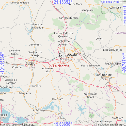
La Negreta GPS coordinates[2]
20° 31' 35.292" North, 100° 27' 1.908" West
| Map corner | latitude | longitude |
|---|---|---|
| Upper-left | 21.18352°, | -101.15366° |
| Center: | 20.52647°, | -100.45053° |
| Lower-right: | 19.86658°, | -99.74741° |
| Map W x H: | 146.4×146.4 km | = 91×91mi |
| max Lat: | 32.7° ⇑31.6% North |
| La Negreta: | 20.52647° |
| min Lat: | ⇓68.4% South 14.53588° |
| min Long | La Negreta | max Long |
| -117.105° | -100.45053° | -86.73105° |
| W 31%⇐ | ⇒69% E |
Elevation
Elevation of La Negreta is 1845 m = 6053 ft, and this is 591.3 m = 1940 ft above average elevation for this country.
| Max E: |
3497 m = 11473 ft | 34.3% |
| La Negreta | 1845 m 6053 ft | |
| Avg. | 1253.7 m = 4113 ft | |
Min E: |
-1 m = -3 ft | 65.7% |
See also: Mexico elevation on elevation.city.
Geographical zone
La Negreta is located in North Torrid zone (between Equator and Tropic of Cancer). Distance of this Northern Tropic circle is 323.6 km =201.1 mi to North.| Distance of | km | miles | from La Negreta |
|---|---|---|---|
| North Pole | 7724.7 | 4799.9 | to North |
| Arctic Circle | 5118.8 | 3180.7 | to North |
| Tropic Cancer | 323.6 | 201.1 | to North |
| Equator | 2282.3 | 1418.2 | to South |


Nearby cities:
15 places around La Negreta: (largest is in red/bold)
• Colonia los Ángeles
4 km =2.5 mi,  283°
283°
• El Castillo
7.5 km =4.7 mi,  323°
323°
• El Paraíso
5.8 km =3.6 mi,  83°
83°
• El Pueblito
2 km =1.2 mi,  40°
40°
• El Romeral
4.8 km =3 mi, 284°
• Joaquín Herrera
5 km =3.1 mi,  165°
165°
• La Norita
7.5 km =4.7 mi,  294°
294°
• Lomas de la Cruz
1.2 km =0.7 mi,  194°
194°
• Los Olvera
4.5 km =2.8 mi, 78°
• Lourdes
3.1 km =1.9 mi,  240°
240°
• San Jose de los Olvera
4.7 km =2.9 mi,  51°
51°
• Valle Dorado Dos Mil
2.2 km =1.4 mi, 277°
• Valle de los Pinos
1.5 km =0.9 mi,  232°
232°
• Venceremos
6.1 km =3.8 mi,  63°
63°
• Vista Real y Country Club
5 km =3.1 mi,  95°
95°
Sources, notices
• [Note1] Compared only with cities in Mexico existing in our database
• [Src1] Map data: © OpenStreetMap contributors (CC-BY-SA)
• [Src2] Other city data from geonames.org with taken over terms of usage.
• [Src3] Geographical zone / Annual Mean Temperature by Robert A. Rohde @ Wikipedia
