La Esperanza geodata
La Esperanza (Coahuila) is a populated place; located in Mexico in America/Monterrey (GMT-6) time zone. With population of 1,447 people, there are 5963 cities with bigger population in this country. Compared to other cities in Mexico, 93% of cities are located further ↓South; 87% of cities are located further →East and 57.3% of cities have higher elevation than La Esperanza. Note1


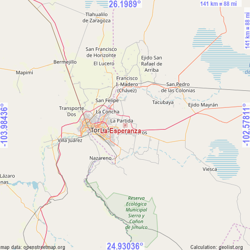
La Esperanza GPS coordinates[2]
25° 33' 58.716" North, 103° 16' 52.428" West
| Map corner | latitude | longitude |
|---|---|---|
| Upper-left | 26.1989°, | -103.98436° |
| Center: | 25.56631°, | -103.28123° |
| Lower-right: | 24.93036°, | -102.57811° |
| Map W x H: | 141×141 km | = 87.6×87.6mi |
| max Lat: | 32.7° ⇑7% North |
| La Esperanza: | 25.56631° |
| min Lat: | ⇓93% South 14.53588° |
| min Long | La Esperanza | max Long |
| -117.105° | -103.28123° | -86.73105° |
| W 13%⇐ | ⇒87% E |
Elevation
Elevation of La Esperanza is 1117 m = 3665 ft, and this is 136.7 m = 448 ft below average elevation for this country.
| Max E: |
3497 m = 11473 ft | 57.3% |
| Avg. | 1253.7 m = 4113 ft | |
| La Esperanza | 1117 m = 3665 ft | |
Min E: |
-1 m = -3 ft | 42.7% |
See also: Mexico elevation on elevation.city.
Geographical zone
La Esperanza is located in North temperate zone (between Tropic of Cancer and the Arctic Circle). Distance of this Northern Tropic circle is 236.8 km =147.1 mi to South.| Distance of | km | miles | from La Esperanza |
|---|---|---|---|
| North Pole | 7164.4 | 4451.8 | to North |
| Arctic Circle | 4558.5 | 2832.5 | to North |
| Tropic Cancer | 236.8 | 147.1 | to South |
| Equator | 2842.7 | 1766.4 | to South |


Nearby cities:
15 places around La Esperanza: (largest is in red/bold)
• Benito Juárez
5.4 km =3.4 mi,  64°
64°
• El Cambio
9.4 km =5.8 mi,  330°
330°
• El Consuelo
0.8 km =0.5 mi,  42°
42°
• El Perú
7.5 km =4.7 mi,  302°
302°
• Fraccionamiento la Noria
6.3 km =3.9 mi,  260°
260°
• Granada
8.5 km =5.3 mi,  9°
9°
• La Corona
2.9 km =1.8 mi,  46°
46°
• La Palma
6.2 km =3.9 mi,  318°
318°
• La Partida
3.4 km =2.1 mi, 326°
• La Paz
8.3 km =5.2 mi,  291°
291°
• Matamoros
6.9 km =4.3 mi,  129°
129°
• Monte Alegre
6.4 km =4 mi,  335°
335°
• Rancho Alegre
8.5 km =5.3 mi,  213°
213°
• Ricardo Flores Magón
9.6 km =6 mi,  310°
310°
• Santa Fé
5.1 km =3.2 mi,  270°
270°
Sources, notices
• [Note1] Compared only with cities in Mexico existing in our database
• [Src1] Map data: © OpenStreetMap contributors (CC-BY-SA)
• [Src2] Other city data from geonames.org with taken over terms of usage.
• [Src3] Geographical zone / Annual Mean Temperature by Robert A. Rohde @ Wikipedia
