Matamoros geodata
Matamoros (Coahuila) is a seat of a second-order administrative division; located in Mexico in America/Monterrey (GMT-6) time zone. With population of 52,233 people, there are 216 cities with bigger population in this country. Compared to other cities in Mexico, 92.8% of cities are located further ↓South; 86.7% of cities are located further →East and 57.3% of cities have higher elevation than Matamoros. Note1


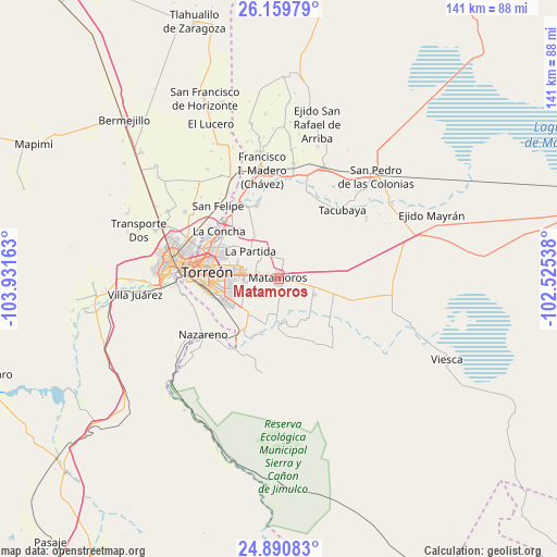
Matamoros GPS coordinates[2]
25° 31' 37.164" North, 103° 13' 42.6" West
| Map corner | latitude | longitude |
|---|---|---|
| Upper-left | 26.15979°, | -103.93163° |
| Center: | 25.52699°, | -103.2285° |
| Lower-right: | 24.89083°, | -102.52538° |
| Map W x H: | 141.1×141.1 km | = 87.7×87.7mi |
| max Lat: | 32.7° ⇑7.2% North |
| Matamoros: | 25.52699° |
| min Lat: | ⇓92.8% South 14.53588° |
| min Long | Matamoros | max Long |
| -117.105° | -103.2285° | -86.73105° |
| W 13.3%⇐ | ⇒86.7% E |
Elevation
Elevation of Matamoros is 1117 m = 3665 ft, and this is 136.7 m = 448 ft below average elevation for this country.
| Max E: |
3497 m = 11473 ft | 57.3% |
| Avg. | 1253.7 m = 4113 ft | |
| Matamoros | 1117 m = 3665 ft | |
Min E: |
-1 m = -3 ft | 42.7% |
See also: Matamoros elevation on elevation.city.
Geographical zone
Matamoros is located in North temperate zone (between Tropic of Cancer and the Arctic Circle). Distance of this Northern Tropic circle is 232.4 km =144.4 mi to South.| Distance of | km | miles | from Matamoros |
|---|---|---|---|
| North Pole | 7168.7 | 4454.4 | to North |
| Arctic Circle | 4562.8 | 2835.2 | to North |
| Tropic Cancer | 232.4 | 144.4 | to South |
| Equator | 2838.3 | 1763.6 | to South |


Nearby cities:
15 places around Matamoros: (largest is in red/bold)
• Benito Juárez
6.7 km =4.2 mi,  356°
356°
• El Consuelo
6.9 km =4.3 mi,  315°
315°
• El Refugio
11.9 km =7.4 mi,  152°
152°
• Fraccionamiento la Noria
12 km =7.5 mi,  286°
286°
• Hidalgo
9.7 km =6 mi,  115°
115°
• La Corona
7.1 km =4.4 mi,  333°
333°
• La Esperanza
6.9 km =4.3 mi,  309°
309°
• La Partida
10.2 km =6.3 mi, 315°
• La Perla
12.7 km =7.9 mi,  254°
254°
• La Rosita
12.7 km =7.9 mi,  181°
181°
• Monte Alegre
12.9 km =8 mi, 322°
• Rancho Alegre
10.3 km =6.4 mi, 254°
• San Pedro
10.5 km =6.5 mi,  173°
173°
• Santa Fé
11.3 km =7 mi, 293°
• Santo Niño Aguanaval
11.8 km =7.3 mi,  205°
205°
Sources, notices
• [Note1] Compared only with cities in Mexico existing in our database
• [Src1] Map data: © OpenStreetMap contributors (CC-BY-SA)
• [Src2] Other city data from geonames.org with taken over terms of usage.
• [Src3] Geographical zone / Annual Mean Temperature by Robert A. Rohde @ Wikipedia
