Tetillas geodata
Tetillas (Zacatecas) is a populated place; located in Mexico in America/Mexico_City (GMT-6) time zone. With population of 1,799 people, there are 4838 cities with bigger population in this country. Compared to other cities in Mexico, 89.3% of cities are located further ↓South; 85.4% of cities are located further →East and 74.7% of cities have lower elevation than Tetillas. Note1


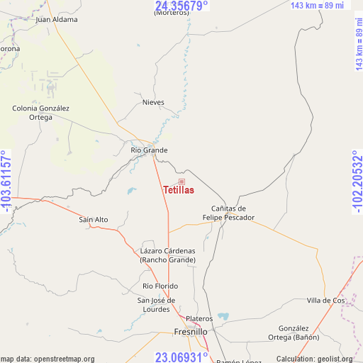
Tetillas GPS coordinates[2]
23° 42' 52.704" North, 102° 54' 30.384" West
| Map corner | latitude | longitude |
|---|---|---|
| Upper-left | 24.35679°, | -103.61157° |
| Center: | 23.71464°, | -102.90844° |
| Lower-right: | 23.06931°, | -102.20532° |
| Map W x H: | 143.2×143.2 km | = 89×89mi |
| max Lat: | 32.7° ⇑10.7% North |
| Tetillas: | 23.71464° |
| min Lat: | ⇓89.3% South 14.53588° |
| min Long | Tetillas | max Long |
| -117.105° | -102.90844° | -86.73105° |
| W 14.6%⇐ | ⇒85.4% E |
Elevation
Elevation of Tetillas is 2025 m = 6644 ft, and this is 771.3 m = 2531 ft above average elevation for this country.
| Max E: |
3497 m = 11473 ft | 25.3% |
| Tetillas | 2025 m 6644 ft | |
| Avg. | 1253.7 m = 4113 ft | |
Min E: |
-1 m = -3 ft | 74.7% |
See also: Mexico elevation on elevation.city.
Geographical zone
Tetillas is located in North temperate zone (between Tropic of Cancer and the Arctic Circle). Distance of this Northern Tropic circle is 30.9 km =19.2 mi to South.| Distance of | km | miles | from Tetillas |
|---|---|---|---|
| North Pole | 7370.2 | 4579.6 | to North |
| Arctic Circle | 4764.4 | 2960.5 | to North |
| Tropic Cancer | 30.9 | 19.2 | to South |
| Equator | 2636.8 | 1638.4 | to South |


Nearby cities:
15 places around Tetillas: (largest is in red/bold)
• Boquilla de Abajo
18.3 km =11.4 mi,  165°
165°
• Boquilla de Arriba
16.6 km =10.3 mi, 174°
• Cañitas de Felipe Pescador
22.2 km =13.8 mi,  123°
123°
• Ciénega y Mancilla
18.8 km =11.7 mi,  297°
297°
• Ignacio López Rayón (Los Delgado)
20.1 km =12.5 mi, 304°
• La Florida
19.8 km =12.3 mi, 300°
• Las Piedras
18.5 km =11.5 mi, 301°
• Loreto
18.3 km =11.4 mi,  325°
325°
• Los Condes
22.2 km =13.8 mi,  308°
308°
• Los Ramírez
19.4 km =12.1 mi,  318°
318°
• Pastelera
19.5 km =12.1 mi,  279°
279°
• Río Grande
17.6 km =10.9 mi, 315°
• San Felipe
21.9 km =13.6 mi,  292°
292°
• San Pablo de Rancho Grande
18.1 km =11.2 mi,  181°
181°
• Tierra Blanca
21.2 km =13.2 mi, 306°
Sources, notices
• [Note1] Compared only with cities in Mexico existing in our database
• [Src1] Map data: © OpenStreetMap contributors (CC-BY-SA)
• [Src2] Other city data from geonames.org with taken over terms of usage.
• [Src3] Geographical zone / Annual Mean Temperature by Robert A. Rohde @ Wikipedia
