Guadalupe geodata
Guadalupe (Nuevo León) is a seat of a second-order administrative division; located in Mexico in America/Monterrey (GMT-6) time zone. With population of 673,616 people, there are 22 cities with bigger population in this country. Compared to other cities in Mexico, 93.5% of cities are located further ↓South; 66.9% of cities are located further →East and 68.5% of cities have higher elevation than Guadalupe. Note1


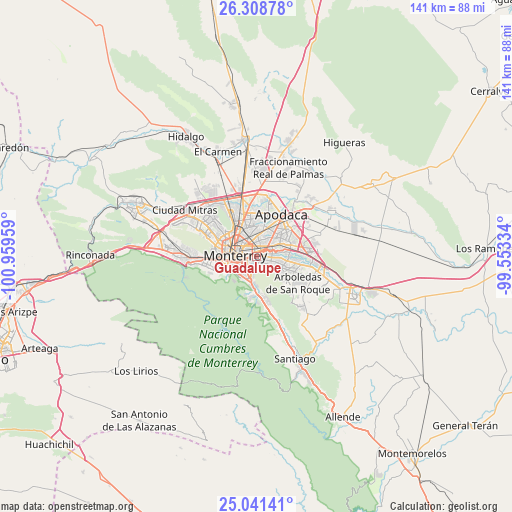
Guadalupe GPS coordinates[2]
25° 40' 36.408" North, 100° 15' 23.256" West
| Map corner | latitude | longitude |
|---|---|---|
| Upper-left | 26.30878°, | -100.95959° |
| Center: | 25.67678°, | -100.25646° |
| Lower-right: | 25.04141°, | -99.55334° |
| Map W x H: | 140.9×140.9 km | = 87.6×87.6mi |
| max Lat: | 32.7° ⇑6.5% North |
| Guadalupe: | 25.67678° |
| min Lat: | ⇓93.5% South 14.53588° |
| min Long | Guadalupe | max Long |
| -117.105° | -100.25646° | -86.73105° |
| W 33.1%⇐ | ⇒66.9% E |
Elevation
Elevation of Guadalupe is 497 m = 1631 ft, and this is 756.7 m = 2483 ft below average elevation for this country.
| Max E: |
3497 m = 11473 ft | 68.5% |
| Avg. | 1253.7 m = 4113 ft | |
| Guadalupe | 497 m = 1631 ft | |
Min E: |
-1 m = -3 ft | 31.5% |
See also: Guadalupe elevation on elevation.city.
Geographical zone
Guadalupe is located in North temperate zone (between Tropic of Cancer and the Arctic Circle). Distance of this Northern Tropic circle is 249.1 km =154.8 mi to South.| Distance of | km | miles | from Guadalupe |
|---|---|---|---|
| North Pole | 7152.1 | 4444.1 | to North |
| Arctic Circle | 4546.2 | 2824.9 | to North |
| Tropic Cancer | 249.1 | 154.8 | to South |
| Equator | 2855 | 1774 | to South |


Nearby cities:
15 places around Guadalupe: (largest is in red/bold)
• Bosques de San Pedro
11.4 km =7.1 mi,  137°
137°
• Centro Habitacional Burócratas de Guadalupe
11.3 km =7 mi,  113°
113°
• Ciudad Apodaca
13.5 km =8.4 mi,  30°
30°
• Fraccionamiento Misión de San Javier
13 km =8.1 mi,  53°
53°
• Héctor Caballero
13.8 km =8.6 mi, 109°
• Jardines de la Silla (Jardines)
8.7 km =5.4 mi,  127°
127°
• Loma la Paz
12.8 km =8 mi,  72°
72°
• Los Olmos
13.2 km =8.2 mi,  61°
61°
• Misión San Pablo
13.3 km =8.3 mi, 58°
• Monte Kristal
11.5 km =7.1 mi,  119°
119°
• Monterrey
6.2 km =3.9 mi,  268°
268°
• Prados de Santa Rosa
13.8 km =8.6 mi,  12°
12°
• San Nicolás de los Garza
8.5 km =5.3 mi,  327°
327°
• Valle de Juárez
10.7 km =6.6 mi, 113°
• Valle de Vaquerías
12 km =7.5 mi, 114°
In other languages:
- In Spanish: Guadalupe, Ciudad Guadalupe
- In German: Ciudad Guadalupe
- In Russian: Гвадалупе
Sources, notices
• [Note1] Compared only with cities in Mexico existing in our database
• [Src1] Map data: © OpenStreetMap contributors (CC-BY-SA)
• [Src2] Other city data from geonames.org with taken over terms of usage.
• [Src3] Geographical zone / Annual Mean Temperature by Robert A. Rohde @ Wikipedia
