Monterrey geodata
Monterrey (Nuevo León) is a seat of a first-order administrative division; located in Mexico in America/Monterrey (GMT-6) time zone. With population of 1,135,512 people, there are 10 cities with bigger population in this country. Compared to other cities in Mexico, 93.5% of cities are located further ↓South; 67.6% of cities are located further →East and 67.7% of cities have higher elevation than Monterrey. Note1


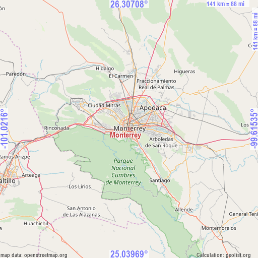
Monterrey GPS coordinates[2]
25° 40' 30.252" North, 100° 19' 6.492" West
| Map corner | latitude | longitude |
|---|---|---|
| Upper-left | 26.30708°, | -101.0216° |
| Center: | 25.67507°, | -100.31847° |
| Lower-right: | 25.03969°, | -99.61535° |
| Map W x H: | 140.9×140.9 km | = 87.6×87.6mi |
| max Lat: | 32.7° ⇑6.5% North |
| Monterrey: | 25.67507° |
| min Lat: | ⇓93.5% South 14.53588° |
| min Long | Monterrey | max Long |
| -117.105° | -100.31847° | -86.73105° |
| W 32.4%⇐ | ⇒67.6% E |
Elevation
Elevation of Monterrey is 543 m = 1781 ft, and this is 710.7 m = 2332 ft below average elevation for this country.
| Max E: |
3497 m = 11473 ft | 67.7% |
| Avg. | 1253.7 m = 4113 ft | |
| Monterrey | 543 m = 1781 ft | |
Min E: |
-1 m = -3 ft | 32.3% |
See also: Monterrey elevation on elevation.city.
Geographical zone
Monterrey is located in North temperate zone (between Tropic of Cancer and the Arctic Circle). Distance of this Northern Tropic circle is 248.9 km =154.7 mi to South.| Distance of | km | miles | from Monterrey |
|---|---|---|---|
| North Pole | 7152.3 | 4444.2 | to North |
| Arctic Circle | 4546.4 | 2825 | to North |
| Tropic Cancer | 248.9 | 154.7 | to South |
| Equator | 2854.8 | 1773.9 | to South |


Nearby cities:
15 places around Monterrey: (largest is in red/bold)
• Bosques de San Pedro
16.1 km =10 mi,  120°
120°
• Centro Habitacional Burócratas de Guadalupe
17.1 km =10.6 mi,  104°
104°
• Ciudad Apodaca
17.6 km =10.9 mi,  47°
47°
• Ciudad General Escobedo
13.6 km =8.5 mi,  0°
0°
• Guadalupe
6.2 km =3.9 mi,  88°
88°
• Jardines de la Silla (Jardines)
14 km =8.7 mi,  111°
111°
• Mitras Poniente
15.5 km =9.6 mi,  316°
316°
• Monclova Segundo Sector
17.5 km =10.9 mi,  333°
333°
• Monte Kristal
17.1 km =10.6 mi, 108°
• Prados de Santa Rosa
16.5 km =10.3 mi,  33°
33°
• San Nicolás de los Garza
7.6 km =4.7 mi,  12°
12°
• San Pedro Garza Garcia
8.7 km =5.4 mi,  256°
256°
• San Pedro Garza García
9 km =5.6 mi, 259°
• Santa Catarina
14 km =8.7 mi,  269°
269°
• Valle de Juárez
16.6 km =10.3 mi, 104°
Sources, notices
• [Note1] Compared only with cities in Mexico existing in our database
• [Src1] Map data: © OpenStreetMap contributors (CC-BY-SA)
• [Src2] Other city data from geonames.org with taken over terms of usage.
• [Src3] Geographical zone / Annual Mean Temperature by Robert A. Rohde @ Wikipedia
