Los Gómez geodata
Los Gómez (San Luis Potosí) is a populated place; located in Mexico in America/Mexico_City (GMT-6) time zone. With population of 835 people, there are 10477 cities with bigger population in this country. Compared to other cities in Mexico, 85% of cities are located further ↓South; 72.5% of cities are located further →East and 65.5% of cities have lower elevation than Los Gómez. Note1


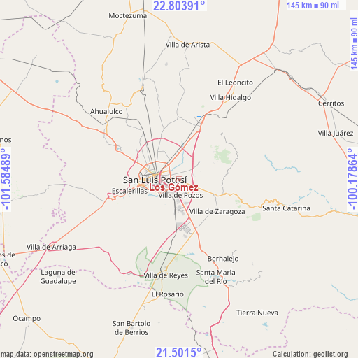
Los Gómez GPS coordinates[2]
22° 9' 15.156" North, 100° 52' 54.336" West
| Map corner | latitude | longitude |
|---|---|---|
| Upper-left | 22.80391°, | -101.58489° |
| Center: | 22.15421°, | -100.88176° |
| Lower-right: | 21.5015°, | -100.17864° |
| Map W x H: | 144.8×144.8 km | = 90×90mi |
| max Lat: | 32.7° ⇑15% North |
| Los Gómez: | 22.15421° |
| min Lat: | ⇓85% South 14.53588° |
| min Long | Los Gómez | max Long |
| -117.105° | -100.88176° | -86.73105° |
| W 27.5%⇐ | ⇒72.5% E |
Elevation
Elevation of Los Gómez is 1842 m = 6043 ft, and this is 588.3 m = 1930 ft above average elevation for this country.
| Max E: |
3497 m = 11473 ft | 34.5% |
| Los Gómez | 1842 m 6043 ft | |
| Avg. | 1253.7 m = 4113 ft | |
Min E: |
-1 m = -3 ft | 65.5% |
See also: Mexico elevation on elevation.city.
Geographical zone
Los Gómez is located in North Torrid zone (between Equator and Tropic of Cancer). Distance of this Northern Tropic circle is 142.6 km =88.6 mi to North.| Distance of | km | miles | from Los Gómez |
|---|---|---|---|
| North Pole | 7543.7 | 4687.4 | to North |
| Arctic Circle | 4937.9 | 3068.3 | to North |
| Tropic Cancer | 142.6 | 88.6 | to North |
| Equator | 2463.3 | 1530.6 | to South |


Nearby cities:
15 places around Los Gómez: (largest is in red/bold)
• Arroyos
11.3 km =7 mi,  192°
192°
• Bosques la Florida
2.8 km =1.7 mi,  101°
101°
• Cerro de San Pedro
11 km =6.8 mi,  50°
50°
• Ciudad Satélite
10.1 km =6.3 mi,  118°
118°
• El Zapote
7.5 km =4.7 mi,  325°
325°
• Enrique Estrada
9.6 km =6 mi,  355°
355°
• Laguna de Santa Rita
5.7 km =3.5 mi,  141°
141°
• Noria San José
10.5 km =6.5 mi,  173°
173°
• Palma de la Cruz
8.3 km =5.2 mi,  8°
8°
• Panalillo
6.9 km =4.3 mi, 95°
• Portezuelo
6 km =3.7 mi,  73°
73°
• Rancho Nuevo
8.7 km =5.4 mi, 330°
• San Luis Potosí
10 km =6.2 mi,  267°
267°
• Soledad de Graciano Sánchez
7 km =4.3 mi,  303°
303°
• Tanque el Jagüey
5.1 km =3.2 mi,  148°
148°
Sources, notices
• [Note1] Compared only with cities in Mexico existing in our database
• [Src1] Map data: © OpenStreetMap contributors (CC-BY-SA)
• [Src2] Other city data from geonames.org with taken over terms of usage.
• [Src3] Geographical zone / Annual Mean Temperature by Robert A. Rohde @ Wikipedia
