El Salado geodata
El Salado (Sinaloa) is a populated place; located in Mexico in America/Mazatlan (GMT-7) time zone. With population of 507 people, there are 16589 cities with bigger population in this country. Compared to other cities in Mexico, 89.7% of cities are located further ↓South; 94.3% of cities are located further →East and 83.9% of cities have higher elevation than El Salado. Note1


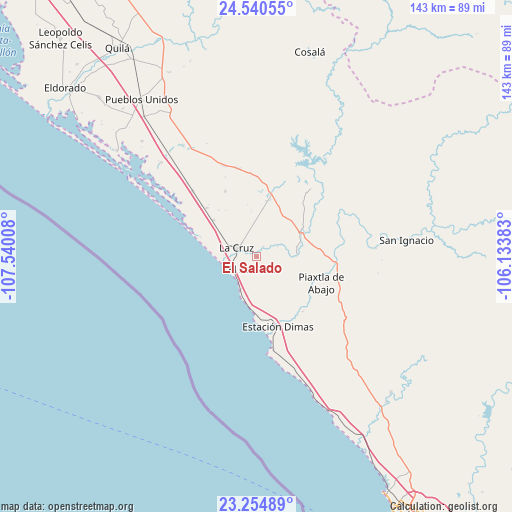
El Salado GPS coordinates[2]
23° 53' 57.552" North, 106° 50' 13.02" West
| Map corner | latitude | longitude |
|---|---|---|
| Upper-left | 24.54055°, | -107.54008° |
| Center: | 23.89932°, | -106.83695° |
| Lower-right: | 23.25489°, | -106.13383° |
| Map W x H: | 143×143 km | = 88.9×88.9mi |
| max Lat: | 32.7° ⇑10.3% North |
| El Salado: | 23.89932° |
| min Lat: | ⇓89.7% South 14.53588° |
| min Long | El Salado | max Long |
| -117.105° | -106.83695° | -86.73105° |
| W 5.7%⇐ | ⇒94.3% E |
Elevation
Elevation of El Salado is 52 m = 171 ft, and this is 1201.7 m = 3943 ft below average elevation for this country.
| Max E: |
3497 m = 11473 ft | 83.9% |
| Avg. | 1253.7 m = 4113 ft | |
| El Salado | 52 m = 171 ft | |
Min E: |
-1 m = -3 ft | 16.1% |
See also: Mexico elevation on elevation.city.
Geographical zone
El Salado is located in North temperate zone (between Tropic of Cancer and the Arctic Circle). Distance of this Northern Tropic circle is 51.4 km =31.9 mi to South.| Distance of | km | miles | from El Salado |
|---|---|---|---|
| North Pole | 7349.7 | 4566.9 | to North |
| Arctic Circle | 4743.8 | 2947.7 | to North |
| Tropic Cancer | 51.4 | 31.9 | to South |
| Equator | 2657.4 | 1651.2 | to South |


Nearby cities:
15 places around El Salado: (largest is in red/bold)
• Casas Viejas
15.7 km =9.8 mi,  10°
10°
• Celestino Gazca Villaseñor
9.9 km =6.2 mi,  206°
206°
• Ceuta
9.3 km =5.8 mi,  270°
270°
• El Bolillo
13.5 km =8.4 mi, 7°
• El Carrizo
12.9 km =8 mi,  353°
353°
• El Roble
3.3 km =2.1 mi,  34°
34°
• El Saladito
3.5 km =2.2 mi,  198°
198°
• Elota
15 km =9.3 mi,  58°
58°
• Emiliano Zapata
20.2 km =12.6 mi,  334°
334°
• Empaque Tarriba
9.6 km =6 mi, 270°
• La Cruz
6.2 km =3.9 mi,  293°
293°
• Piaxtla de Abajo
19.5 km =12.1 mi,  112°
112°
• Potrerillo del Norote
19.4 km =12.1 mi,  314°
314°
• Pueblo Nuevo
15.9 km =9.9 mi, 310°
• Tayoltita
5 km =3.1 mi, 214°
Sources, notices
• [Note1] Compared only with cities in Mexico existing in our database
• [Src1] Map data: © OpenStreetMap contributors (CC-BY-SA)
• [Src2] Other city data from geonames.org with taken over terms of usage.
• [Src3] Geographical zone / Annual Mean Temperature by Robert A. Rohde @ Wikipedia
