Cosalá geodata
Cosalá (Sinaloa) is a seat of a second-order administrative division; located in Mexico in America/Mazatlan (GMT-7) time zone. With population of 6,577 people, there are 1423 cities with bigger population in this country. Compared to other cities in Mexico, 90.7% of cities are located further ↓South; 94.2% of cities are located further →East and 70.6% of cities have higher elevation than Cosalá. Note1


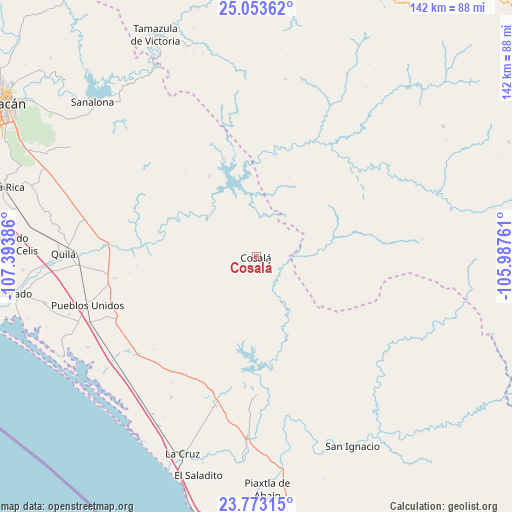
Cosalá GPS coordinates[2]
24° 24' 54.036" North, 106° 41' 26.628" West
| Map corner | latitude | longitude |
|---|---|---|
| Upper-left | 25.05362°, | -107.39386° |
| Center: | 24.41501°, | -106.69073° |
| Lower-right: | 23.77315°, | -105.98761° |
| Map W x H: | 142.4×142.4 km | = 88.5×88.5mi |
| max Lat: | 32.7° ⇑9.3% North |
| Cosalá: | 24.41501° |
| min Lat: | ⇓90.7% South 14.53588° |
| min Long | Cosalá | max Long |
| -117.105° | -106.69073° | -86.73105° |
| W 5.8%⇐ | ⇒94.2% E |
Elevation
Elevation of Cosalá is 389 m = 1276 ft, and this is 864.7 m = 2837 ft below average elevation for this country.
| Max E: |
3497 m = 11473 ft | 70.6% |
| Avg. | 1253.7 m = 4113 ft | |
| Cosalá | 389 m = 1276 ft | |
Min E: |
-1 m = -3 ft | 29.4% |
See also: Mexico elevation on elevation.city.
Geographical zone
Cosalá is located in North temperate zone (between Tropic of Cancer and the Arctic Circle). Distance of this Northern Tropic circle is 108.8 km =67.6 mi to South.| Distance of | km | miles | from Cosalá |
|---|---|---|---|
| North Pole | 7292.4 | 4531.3 | to North |
| Arctic Circle | 4686.5 | 2912.1 | to North |
| Tropic Cancer | 108.8 | 67.6 | to South |
| Equator | 2714.7 | 1686.8 | to South |


Nearby cities:
15 places around Cosalá: (largest is in red/bold)
• Casas Viejas
43.6 km =27.1 mi,  196°
196°
• Chiqueritos
43.9 km =27.3 mi,  233°
233°
• El Bolillo
45.9 km =28.5 mi, 196°
• El Carrizo
47.5 km =29.5 mi, 200°
• El Espinal
38.5 km =23.9 mi,  212°
212°
• Emiliano Zapata
45.7 km =28.4 mi, 211°
• Estación Obispo
49.4 km =30.7 mi,  254°
254°
• Higueras de Abuya
42.2 km =26.2 mi, 245°
• Obispo
43.3 km =26.9 mi, 254°
• Oso Viejo
48.7 km =30.3 mi,  267°
267°
• Pueblos Unidos
48.6 km =30.2 mi, 253°
• Salado
48.5 km =30.1 mi,  282°
282°
• San Francisco de Tacuichamona
39.5 km =24.5 mi,  261°
261°
• San José de Conitaca (Nuevo Conitaca)
38.1 km =23.7 mi, 210°
• Tabalá
41.1 km =25.5 mi, 274°
Sources, notices
• [Note1] Compared only with cities in Mexico existing in our database
• [Src1] Map data: © OpenStreetMap contributors (CC-BY-SA)
• [Src2] Other city data from geonames.org with taken over terms of usage.
• [Src3] Geographical zone / Annual Mean Temperature by Robert A. Rohde @ Wikipedia
