Colorines geodata
Colorines (State of Mexico) is a populated place; located in Mexico in America/Mexico_City (GMT-6) time zone. With population of 5,543 people, there are 1685 cities with bigger population in this country. Compared to other cities in Mexico, 61.6% of cities are located further ↑North; 66.6% of cities are located further →East and 56.2% of cities have lower elevation than Colorines. Note1


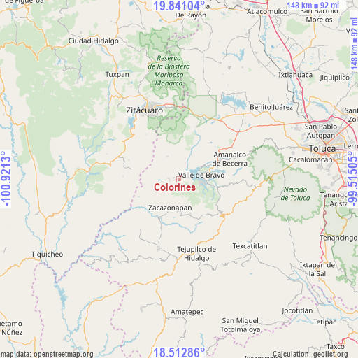
Colorines GPS coordinates[2]
19° 10' 41.844" North, 100° 13' 5.412" West
| Map corner | latitude | longitude |
|---|---|---|
| Upper-left | 19.84104°, | -100.9213° |
| Center: | 19.17829°, | -100.21817° |
| Lower-right: | 18.51286°, | -99.51505° |
| Map W x H: | 147.7×147.7 km | = 91.8×91.8mi |
| max Lat: | 32.7° ⇑61.6% North |
| Colorines: | 19.17829° |
| min Lat: | ⇓38.4% South 14.53588° |
| min Long | Colorines | max Long |
| -117.105° | -100.21817° | -86.73105° |
| W 33.4%⇐ | ⇒66.6% E |
Elevation
Elevation of Colorines is 1625 m = 5331 ft, and this is 371.3 m = 1218 ft above average elevation for this country.
| Max E: |
3497 m = 11473 ft | 43.8% |
| Colorines | 1625 m 5331 ft | |
| Avg. | 1253.7 m = 4113 ft | |
Min E: |
-1 m = -3 ft | 56.2% |
See also: Mexico elevation on elevation.city.
Geographical zone
Colorines is located in North Torrid zone (between Equator and Tropic of Cancer). Distance of this Northern Tropic circle is 473.5 km =294.2 mi to North.| Distance of | km | miles | from Colorines |
|---|---|---|---|
| North Pole | 7874.6 | 4893 | to North |
| Arctic Circle | 5268.7 | 3273.8 | to North |
| Tropic Cancer | 473.5 | 294.2 | to North |
| Equator | 2132.4 | 1325 | to South |


Nearby cities:
15 places around Colorines: (largest is in red/bold)
• Cerro Gordo
9.1 km =5.7 mi,  125°
125°
• El Arco
10.5 km =6.5 mi,  60°
60°
• El Durazno
2.8 km =1.7 mi,  37°
37°
• El Sifón
1.5 km =0.9 mi,  265°
265°
• Frontón Vivero
0.8 km =0.5 mi,  251°
251°
• Las Fincas
4.2 km =2.6 mi,  263°
263°
• Loma Bonita
1 km =0.6 mi,  18°
18°
• Rincón Chico
1.2 km =0.7 mi,  186°
186°
• San Gaspar
10.1 km =6.3 mi, 56°
• San Juan Atezcapan
3.7 km =2.3 mi,  109°
109°
• San Nicolás Tolentino
2.5 km =1.6 mi,  286°
286°
• Santa Teresa Tiloxtoc
6 km =3.7 mi, 20°
• Santo Tomás de los Plátanos
4.4 km =2.7 mi,  276°
276°
• Tutuapan
8.3 km =5.2 mi,  321°
321°
• Valle de Bravo
9.3 km =5.8 mi,  78°
78°
Sources, notices
• [Note1] Compared only with cities in Mexico existing in our database
• [Src1] Map data: © OpenStreetMap contributors (CC-BY-SA)
• [Src2] Other city data from geonames.org with taken over terms of usage.
• [Src3] Geographical zone / Annual Mean Temperature by Robert A. Rohde @ Wikipedia
