Vicente Guerrero geodata
Vicente Guerrero (Baja California) is a populated place; located in Mexico in America/Tijuana (GMT-7) time zone. With population of 11,455 people, there are 843 cities with bigger population in this country. Compared to other cities in Mexico, 98.8% of cities are located further ↓South; 99.5% of cities are located further →East and 88.6% of cities have higher elevation than Vicente Guerrero. Note1


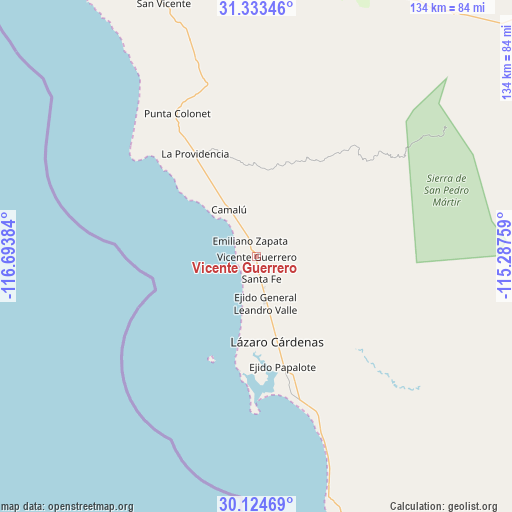
Vicente Guerrero GPS coordinates[2]
30° 43' 51.492" North, 115° 59' 26.556" West
| Map corner | latitude | longitude |
|---|---|---|
| Upper-left | 31.33346°, | -116.69384° |
| Center: | 30.73097°, | -115.99071° |
| Lower-right: | 30.12469°, | -115.28759° |
| Map W x H: | 134.4×134.4 km | = 83.5×83.5mi |
| max Lat: | 32.7° ⇑1.2% North |
| Vicente Guerrero: | 30.73097° |
| min Lat: | ⇓98.8% South 14.53588° |
| min Long | Vicente Guerrer | max Long |
| -117.105° | -115.99071° | -86.73105° |
| W 0.5%⇐ | ⇒99.5% E |
Elevation
Elevation of Vicente Guerrero is 28 m = 92 ft, and this is 1225.7 m = 4021 ft below average elevation for this country.
| Max E: |
3497 m = 11473 ft | 88.6% |
| Avg. | 1253.7 m = 4113 ft | |
| Vicente Guerrero | 28 m = 92 ft | |
Min E: |
-1 m = -3 ft | 11.4% |
See also: Mexico elevation on elevation.city.
Geographical zone
Vicente Guerrero is located in North temperate zone (between Tropic of Cancer and the Arctic Circle). Distance of this Northern Tropic circle is 811 km =503.9 mi to South.| Distance of | km | miles | from Vicente Guerrero |
|---|---|---|---|
| North Pole | 6590.1 | 4094.9 | to North |
| Arctic Circle | 3984.2 | 2475.7 | to North |
| Tropic Cancer | 811 | 503.9 | to South |
| Equator | 3417 | 2123.2 | to South |


Nearby cities:
15 places around Vicente Guerrero: (largest is in red/bold)
• Camalú
14.2 km =8.8 mi,  330°
330°
• Colonia Lomas de San Ramón (Triquis)
3.5 km =2.2 mi,  199°
199°
• Colonia Militar Elpidio Berlanga de León
8.4 km =5.2 mi,  335°
335°
• Colonia Nueva Era
25.8 km =16 mi,  165°
165°
• Ejido General Leandro Valle
12.4 km =7.7 mi, 168°
• Emiliano Zapata
2.8 km =1.7 mi, 335°
• La Providencia
30.9 km =19.2 mi, 328°
• Las Brisas
30.4 km =18.9 mi, 326°
• Lázaro Cárdenas
23.4 km =14.5 mi,  164°
164°
• Playas de la Vicente Guerrero
5.4 km =3.4 mi, 172°
• Poblado Chulavista (El Chorizo)
2.2 km =1.4 mi, 326°
• Pueblo Benito García
24.6 km =15.3 mi, 166°
• San Quintín
18.2 km =11.3 mi, 166°
• Santa Candelaria
13 km =8.1 mi, 328°
• Santa Fé
5.8 km =3.6 mi, 166°
Sources, notices
• [Note1] Compared only with cities in Mexico existing in our database
• [Src1] Map data: © OpenStreetMap contributors (CC-BY-SA)
• [Src2] Other city data from geonames.org with taken over terms of usage.
• [Src3] Geographical zone / Annual Mean Temperature by Robert A. Rohde @ Wikipedia
