Ahome geodata
Ahome (Sinaloa) is a populated place; located in Mexico in America/Mazatlan (GMT-7) time zone. With population of 11,331 people, there are 844 cities with bigger population in this country. Compared to other cities in Mexico, 95% of cities are located further ↓South; 97.2% of cities are located further →East and 95.1% of cities have higher elevation than Ahome. Note1


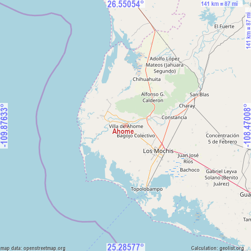
Ahome GPS coordinates[2]
25° 55' 11.46" North, 109° 10' 23.52" West
| Map corner | latitude | longitude |
|---|---|---|
| Upper-left | 26.55054°, | -109.87633° |
| Center: | 25.91985°, | -109.1732° |
| Lower-right: | 25.28577°, | -108.47008° |
| Map W x H: | 140.6×140.6 km | = 87.4×87.4mi |
| max Lat: | 32.7° ⇑5% North |
| Ahome: | 25.91985° |
| min Lat: | ⇓95% South 14.53588° |
| min Long | Ahome | max Long |
| -117.105° | -109.1732° | -86.73105° |
| W 2.8%⇐ | ⇒97.2% E |
Elevation
Elevation of Ahome is 13 m = 43 ft, and this is 1240.7 m = 4071 ft below average elevation for this country.
| Max E: |
3497 m = 11473 ft | 95.1% |
| Avg. | 1253.7 m = 4113 ft | |
| Ahome | 13 m = 43 ft | |
Min E: |
-1 m = -3 ft | 4.9% |
See also: Mexico elevation on elevation.city.
Geographical zone
Ahome is located in North temperate zone (between Tropic of Cancer and the Arctic Circle). Distance of this Northern Tropic circle is 276.1 km =171.6 mi to South.| Distance of | km | miles | from Ahome |
|---|---|---|---|
| North Pole | 7125 | 4427.3 | to North |
| Arctic Circle | 4519.2 | 2808.1 | to North |
| Tropic Cancer | 276.1 | 171.6 | to South |
| Equator | 2882 | 1790.8 | to South |


Nearby cities:
15 places around Ahome: (largest is in red/bold)
• Agua Nueva
8.8 km =5.5 mi,  116°
116°
• Bagojo Colectivo
7.5 km =4.7 mi,  132°
132°
• Cuchilla de Cachoana
7.8 km =4.8 mi, 126°
• Ejido Cohuibampo
2.8 km =1.7 mi,  31°
31°
• Ejido Mayocoba
5.2 km =3.2 mi,  293°
293°
• Ejido Tosalibampo
9.1 km =5.7 mi,  41°
41°
• El Guayabo
4.2 km =2.6 mi,  55°
55°
• El Porvenir
7.7 km =4.8 mi,  79°
79°
• Goros Pueblo
10.2 km =6.3 mi,  67°
67°
• Heriberto Valdez Romero (El Guayabo)
4.3 km =2.7 mi, 57°
• Los Suárez
4 km =2.5 mi,  334°
334°
• Macapul (Almacenes)
5.4 km =3.4 mi, 133°
• Macapule
4.5 km =2.8 mi,  146°
146°
• San Isidro
10.1 km =6.3 mi,  309°
309°
• Vallejo (Porvenir Vallejo)
10.8 km =6.7 mi,  112°
112°
Sources, notices
• [Note1] Compared only with cities in Mexico existing in our database
• [Src1] Map data: © OpenStreetMap contributors (CC-BY-SA)
• [Src2] Other city data from geonames.org with taken over terms of usage.
• [Src3] Geographical zone / Annual Mean Temperature by Robert A. Rohde @ Wikipedia
