Laguna Larga geodata
Laguna Larga (Guanajuato) is a populated place; located in Mexico in America/Mexico_City (GMT-6) time zone. With population of 1,167 people, there are 7434 cities with bigger population in this country. Compared to other cities in Mexico, 68.7% of cities are located further ↓South; 77.3% of cities are located further →East and 58.8% of cities have lower elevation than Laguna Larga. Note1


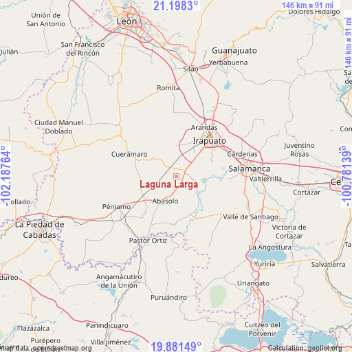
Laguna Larga GPS coordinates[2]
20° 32' 28.716" North, 101° 29' 4.236" West
| Map corner | latitude | longitude |
|---|---|---|
| Upper-left | 21.1983°, | -102.18764° |
| Center: | 20.54131°, | -101.48451° |
| Lower-right: | 19.88149°, | -100.78139° |
| Map W x H: | 146.4×146.4 km | = 91×91mi |
| max Lat: | 32.7° ⇑31.3% North |
| Laguna Larga: | 20.54131° |
| min Lat: | ⇓68.7% South 14.53588° |
| min Long | Laguna Larga | max Long |
| -117.105° | -101.48451° | -86.73105° |
| W 22.7%⇐ | ⇒77.3% E |
Elevation
Elevation of Laguna Larga is 1704 m = 5591 ft, and this is 450.3 m = 1477 ft above average elevation for this country.
| Max E: |
3497 m = 11473 ft | 41.2% |
| Laguna Larga | 1704 m 5591 ft | |
| Avg. | 1253.7 m = 4113 ft | |
Min E: |
-1 m = -3 ft | 58.8% |
See also: Mexico elevation on elevation.city.
Geographical zone
Laguna Larga is located in North Torrid zone (between Equator and Tropic of Cancer). Distance of this Northern Tropic circle is 321.9 km =200 mi to North.| Distance of | km | miles | from Laguna Larga |
|---|---|---|---|
| North Pole | 7723.1 | 4798.9 | to North |
| Arctic Circle | 5117.2 | 3179.7 | to North |
| Tropic Cancer | 321.9 | 200 | to North |
| Equator | 2284 | 1419.2 | to South |


Nearby cities:
15 places around Laguna Larga: (largest is in red/bold)
• Colonia Hermosillo
6.2 km =3.9 mi,  312°
312°
• Colonia Morelos de Guadalupe de Rivera
7.1 km =4.4 mi,  31°
31°
• El Romeral
5.2 km =3.2 mi, 28°
• Estación Joaquín
4.3 km =2.7 mi,  300°
300°
• Guadalupe de Rivera
7.3 km =4.5 mi,  14°
14°
• La Trinidad
4.7 km =2.9 mi,  356°
356°
• Munguía
2.1 km =1.3 mi,  100°
100°
• Purísima de Covarrubias
8.7 km =5.4 mi,  0°
0°
• Rivera de Guadalupe
8.3 km =5.2 mi,  17°
17°
• San Francisco de Horta (El Alacrán)
8.2 km =5.1 mi, 298°
• San Ignacio de Rivera (Ojo de Agua)
3.1 km =1.9 mi,  50°
50°
• San Isidro
8.7 km =5.4 mi,  186°
186°
• San José de González
5.7 km =3.5 mi,  222°
222°
• San Luis del Jánamo (El Morado)
6.2 km =3.9 mi, 30°
• San Miguel del Brete
4.9 km =3 mi,  76°
76°
Sources, notices
• [Note1] Compared only with cities in Mexico existing in our database
• [Src1] Map data: © OpenStreetMap contributors (CC-BY-SA)
• [Src2] Other city data from geonames.org with taken over terms of usage.
• [Src3] Geographical zone / Annual Mean Temperature by Robert A. Rohde @ Wikipedia
