Potrerillos (Guanajal) geodata
Potrerillos (Guanajal) (Guanajuato) is a populated place; located in Mexico in America/Mexico_City (GMT-6) time zone. With population of 1,976 people, there are 4412 cities with bigger population in this country. Compared to other cities in Mexico, 77.6% of cities are located further ↓South; 80.1% of cities are located further →East and 63.7% of cities have lower elevation than Potrerillos (Guanajal). Note1
Current local time in Potrerillos (Guanajal):
06:47 AM, WednesdayDifference from your time zone: hours


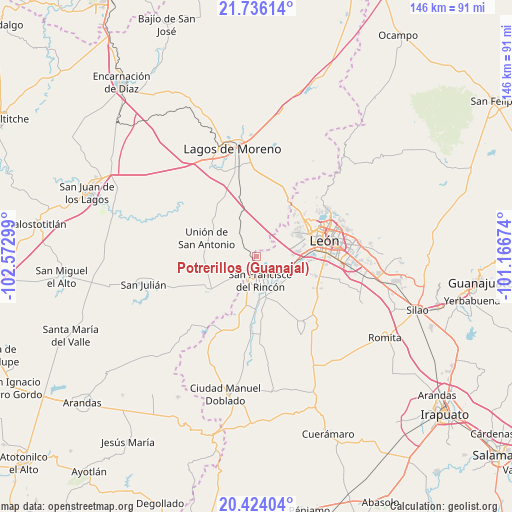
Potrerillos (Guanajal) GPS coordinates[2]
21° 4' 53.544" North, 101° 52' 11.496" West
| Map corner | latitude | longitude |
|---|---|---|
| Upper-left | 21.73614°, | -102.57299° |
| Center: | 21.08154°, | -101.86986° |
| Lower-right: | 20.42404°, | -101.16674° |
| Map W x H: | 145.9×145.9 km | = 90.7×90.7mi |
| max Lat: | 32.7° ⇑22.4% North |
| Potrerillos (Guanajal): | 21.08154° |
| min Lat: | ⇓77.6% South 14.53588° |
| min Long | Potrerillos (Gu | max Long |
| -117.105° | -101.86986° | -86.73105° |
| W 19.9%⇐ | ⇒80.1% E |
Elevation
Elevation of Potrerillos (Guanajal) is 1793 m = 5883 ft, and this is 539.3 m = 1769 ft above average elevation for this country.
| Max E: |
3497 m = 11473 ft | 36.3% |
| Potrerillos (Guanajal) | 1793 m 5883 ft | |
| Avg. | 1253.7 m = 4113 ft | |
Min E: |
-1 m = -3 ft | 63.7% |
See also: Mexico elevation on elevation.city.
Geographical zone
Potrerillos (Guanajal) is located in North Torrid zone (between Equator and Tropic of Cancer). Distance of this Northern Tropic circle is 261.9 km =162.7 mi to North.| Distance of | km | miles | from Potrerillos (Guanajal) |
|---|---|---|---|
| North Pole | 7663 | 4761.6 | to North |
| Arctic Circle | 5057.1 | 3142.3 | to North |
| Tropic Cancer | 261.9 | 162.7 | to North |
| Equator | 2344 | 1456.5 | to South |


Nearby cities:
15 places around Potrerillos (Guanajal): (largest is in red/bold)
• Arroyo Seco
10.9 km =6.8 mi,  148°
148°
• Buenavista
8.9 km =5.5 mi,  115°
115°
• Cañada de Soto
6 km =3.7 mi,  112°
112°
• Estación de San Francisco
6.8 km =4.2 mi,  136°
136°
• Fraccionamiento Villa Jardín
10.2 km =6.3 mi,  169°
169°
• Fraccionamiento la Mezquitera
8.8 km =5.5 mi,  155°
155°
• Monte Grande
9.3 km =5.8 mi,  175°
175°
• Pedrito [Estación]
7.4 km =4.6 mi,  322°
322°
• Purísima de Bustos
5.6 km =3.5 mi,  188°
188°
• Rincones de la Pradera
6.8 km =4.2 mi, 118°
• San Francisco del Rincón
7.2 km =4.5 mi, 167°
• San Jerónimo
10.1 km =6.3 mi, 183°
• San José del Caliche (El Caliche)
7.9 km =4.9 mi,  307°
307°
• San Nicolás del Palenque
11.2 km =7 mi,  197°
197°
• San Roque de Montes
10 km =6.2 mi, 142°
Sources, notices
• [Note1] Compared only with cities in Mexico existing in our database
• [Src1] Map data: © OpenStreetMap contributors (CC-BY-SA)
• [Src2] Other city data from geonames.org with taken over terms of usage.
• [Src3] Geographical zone / Annual Mean Temperature by Robert A. Rohde @ Wikipedia
