Monte Grande geodata
Monte Grande (Guanajuato) is a populated place; located in Mexico in America/Mexico_City (GMT-6) time zone. With population of 1,999 people, there are 4355 cities with bigger population in this country. Compared to other cities in Mexico, 76.4% of cities are located further ↓South; 80.1% of cities are located further →East and 61.6% of cities have lower elevation than Monte Grande. Note1


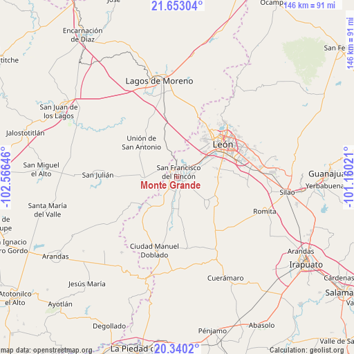
Monte Grande GPS coordinates[2]
20° 59' 53.016" North, 101° 51' 47.988" West
| Map corner | latitude | longitude |
|---|---|---|
| Upper-left | 21.65304°, | -102.56646° |
| Center: | 20.99806°, | -101.86333° |
| Lower-right: | 20.3402°, | -101.16021° |
| Map W x H: | 146×146 km | = 90.7×90.7mi |
| max Lat: | 32.7° ⇑23.6% North |
| Monte Grande: | 20.99806° |
| min Lat: | ⇓76.4% South 14.53588° |
| min Long | Monte Grande | max Long |
| -117.105° | -101.86333° | -86.73105° |
| W 19.9%⇐ | ⇒80.1% E |
Elevation
Elevation of Monte Grande is 1751 m = 5745 ft, and this is 497.3 m = 1632 ft above average elevation for this country.
| Max E: |
3497 m = 11473 ft | 38.4% |
| Monte Grande | 1751 m 5745 ft | |
| Avg. | 1253.7 m = 4113 ft | |
Min E: |
-1 m = -3 ft | 61.6% |
See also: Mexico elevation on elevation.city.
Geographical zone
Monte Grande is located in North Torrid zone (between Equator and Tropic of Cancer). Distance of this Northern Tropic circle is 271.2 km =168.5 mi to North.| Distance of | km | miles | from Monte Grande |
|---|---|---|---|
| North Pole | 7672.3 | 4767.3 | to North |
| Arctic Circle | 5066.4 | 3148.1 | to North |
| Tropic Cancer | 271.2 | 168.5 | to North |
| Equator | 2334.8 | 1450.8 | to South |


Nearby cities:
15 places around Monte Grande: (largest is in red/bold)
• Arroyo Seco
5.1 km =3.2 mi,  89°
89°
• Dolores
6.7 km =4.2 mi,  216°
216°
• El Maguey
2.6 km =1.6 mi,  138°
138°
• El Refugio
5.2 km =3.2 mi, 222°
• Estación de San Francisco
5.9 km =3.7 mi,  42°
42°
• Fraccionamiento Villa Jardín
1.4 km =0.9 mi,  121°
121°
• Fraccionamiento la Mezquitera
3.2 km =2 mi,  66°
66°
• Purísima de Bustos
4 km =2.5 mi,  337°
337°
• San Bernardo
3.4 km =2.1 mi,  191°
191°
• San Francisco del Rincón
2.4 km =1.5 mi,  20°
20°
• San Jerónimo
1.5 km =0.9 mi,  237°
237°
• San Nicolás del Palenque
4.3 km =2.7 mi,  251°
251°
• San Roque de Montes
5.6 km =3.5 mi,  76°
76°
• San Roque de Torres
3.2 km =2 mi,  159°
159°
• Silva
5.8 km =3.6 mi,  173°
173°
Sources, notices
• [Note1] Compared only with cities in Mexico existing in our database
• [Src1] Map data: © OpenStreetMap contributors (CC-BY-SA)
• [Src2] Other city data from geonames.org with taken over terms of usage.
• [Src3] Geographical zone / Annual Mean Temperature by Robert A. Rohde @ Wikipedia
