La Salud geodata
La Salud (Michoacán) is a populated place; located in Mexico in America/Mexico_City (GMT-6) time zone. With population of 891 people, there are 9789 cities with bigger population in this country. Compared to other cities in Mexico, 51.9% of cities are located further ↑North; 67.2% of cities are located further →East and 99.7% of cities have lower elevation than La Salud. Note1


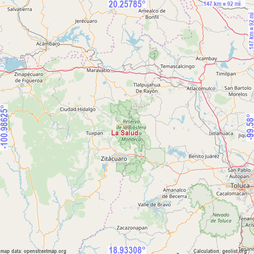
La Salud GPS coordinates[2]
19° 35' 48.588" North, 100° 16' 59.232" West
| Map corner | latitude | longitude |
|---|---|---|
| Upper-left | 20.25785°, | -100.98625° |
| Center: | 19.59683°, | -100.28312° |
| Lower-right: | 18.93308°, | -99.58° |
| Map W x H: | 147.3×147.3 km | = 91.5×91.5mi |
| max Lat: | 32.7° ⇑51.9% North |
| La Salud: | 19.59683° |
| min Lat: | ⇓48.1% South 14.53588° |
| min Long | La Salud | max Long |
| -117.105° | -100.28312° | -86.73105° |
| W 32.8%⇐ | ⇒67.2% E |
Elevation
Elevation of La Salud is 2948 m = 9672 ft, and this is 1694.3 m = 5559 ft above average elevation for this country.
| Max E: |
3497 m = 11473 ft | 0.3% |
| La Salud | 2948 m 9672 ft | |
| Avg. | 1253.7 m = 4113 ft | |
Min E: |
-1 m = -3 ft | 99.7% |
See also: Mexico elevation on elevation.city.
Geographical zone
La Salud is located in North Torrid zone (between Equator and Tropic of Cancer). Distance of this Northern Tropic circle is 427 km =265.3 mi to North.| Distance of | km | miles | from La Salud |
|---|---|---|---|
| North Pole | 7828.1 | 4864.2 | to North |
| Arctic Circle | 5222.2 | 3244.9 | to North |
| Tropic Cancer | 427 | 265.3 | to North |
| Equator | 2179 | 1354 | to South |


Nearby cities:
15 places around La Salud: (largest is in red/bold)
• Cerro Prieto
1.3 km =0.8 mi,  219°
219°
• Cieneguillas
2.9 km =1.8 mi,  227°
227°
• Colonia Independencia
4.8 km =3 mi,  295°
295°
• Cuartel la Mesa (El Asoleadero)
3 km =1.9 mi,  187°
187°
• Cuartel las Palmas
2.2 km =1.4 mi,  157°
157°
• Ejido el Rosario
2.9 km =1.8 mi,  166°
166°
• El Soldado Anónimo
6.5 km =4 mi,  273°
273°
• Jesús de Nazareno (La Hacienda)
5.6 km =3.5 mi, 302°
• La Rondanilla (Primer Cuartel)
7.4 km =4.6 mi, 302°
• Manzana Rancho Escondido
1.5 km =0.9 mi,  141°
141°
• Manzana de San Luis
3.9 km =2.4 mi, 170°
• Manzana de la Trinidad (La Junta)
3.4 km =2.1 mi, 298°
• Manzana la Cantera
1.4 km =0.9 mi,  203°
203°
• Mineral de Angangueo
2.6 km =1.6 mi,  357°
357°
• Ocampo
6.1 km =3.8 mi,  254°
254°
Sources, notices
• [Note1] Compared only with cities in Mexico existing in our database
• [Src1] Map data: © OpenStreetMap contributors (CC-BY-SA)
• [Src2] Other city data from geonames.org with taken over terms of usage.
• [Src3] Geographical zone / Annual Mean Temperature by Robert A. Rohde @ Wikipedia
