Ciudad Lázaro Cárdenas geodata
Ciudad Lázaro Cárdenas (Michoacán) is a populated place; located in Mexico in America/Mexico_City (GMT-6) time zone. With population of 79,200 people, there are 156 cities with bigger population in this country. Compared to other cities in Mexico, 79% of cities are located further ↑North; 82.1% of cities are located further →East and 89% of cities have higher elevation than Ciudad Lázaro Cárdenas. Note1
Current local time in Ciudad Lázaro Cárdenas:
08:41 PM, TuesdayDifference from your time zone: hours


Ciudad Lázaro Cárdenas GPS coordinates[2]
17° 58' 14.376" North, 102° 13' 16.464" West
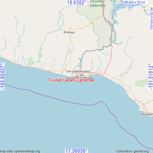
| Map corner | latitude | longitude |
|---|---|---|
| Upper-left | 18.6382°, | -102.92437° |
| Center: | 17.97066°, | -102.22124° |
| Lower-right: | 17.30058°, | -101.51812° |
| Map W x H: | 148.7×148.7 km | = 92.4×92.4mi |
| max Lat: | 32.7° ⇑79% North |
| Ciudad Lázaro Cárdenas: | 17.97066° |
| min Lat: | ⇓21% South 14.53588° |
| min Long | Ciudad Lázaro | max Long |
| -117.105° | -102.22124° | -86.73105° |
| W 17.9%⇐ | ⇒82.1% E |
Elevation
Elevation of Ciudad Lázaro Cárdenas is 27 m = 89 ft, and this is 1226.7 m = 4025 ft below average elevation for this country.
| Max E: |
3497 m = 11473 ft | 89% |
| Avg. | 1253.7 m = 4113 ft | |
| Ciudad Lázaro Cárdenas | 27 m = 89 ft | |
Min E: |
-1 m = -3 ft | 11% |
See also: Ciudad Lázaro Cárdenas elevation on elevation.city.
Geographical zone
Ciudad Lázaro Cárdenas is located in North Torrid zone (between Equator and Tropic of Cancer). Distance of this Northern Tropic circle is 607.8 km =377.7 mi to North.| Distance of | km | miles | from Ciudad Lázaro Cárdenas |
|---|---|---|---|
| North Pole | 8008.9 | 4976.5 | to North |
| Arctic Circle | 5403 | 3357.3 | to North |
| Tropic Cancer | 607.8 | 377.7 | to North |
| Equator | 1998.2 | 1241.6 | to South |


Nearby cities:
15 places around Ciudad Lázaro Cárdenas: (largest is in red/bold)
• Acalpican de Morelos
13.7 km =8.5 mi,  292°
292°
• Buenos Aires
9.1 km =5.7 mi,  311°
311°
• El Bordonal
10.4 km =6.5 mi, 291°
• El Habillal
16.5 km =10.3 mi,  284°
284°
• El Naranjito
7 km =4.3 mi,  74°
74°
• Guacamayas
5.5 km =3.4 mi,  9°
9°
• La Mira
13.1 km =8.1 mi,  302°
302°
• La Orilla
2.9 km =1.8 mi,  347°
347°
• Petacalco
12 km =7.5 mi,  84°
84°
• Playa Azul
13.4 km =8.3 mi, 275°
• Puente de la Vía
5.2 km =3.2 mi,  321°
321°
• San Francisco
9.7 km =6 mi,  86°
86°
• Surcua
15.5 km =9.6 mi, 74°
• Tamacuas (El Ranchito)
8.2 km =5.1 mi,  33°
33°
• Zacatula
6.2 km =3.9 mi,  45°
45°
Sources, notices
• [Note1] Compared only with cities in Mexico existing in our database
• [Src1] Map data: © OpenStreetMap contributors (CC-BY-SA)
• [Src2] Other city data from geonames.org with taken over terms of usage.
• [Src3] Geographical zone / Annual Mean Temperature by Robert A. Rohde @ Wikipedia
