Playa Azul geodata
Playa Azul (State of Mexico) is a populated place; located in Mexico in America/Mexico_City (GMT-6) time zone. With population of 3,139 people, there are 2879 cities with bigger population in this country. Compared to other cities in Mexico, 78.9% of cities are located further ↑North; 83.2% of cities are located further →East and 97.5% of cities have higher elevation than Playa Azul. Note1


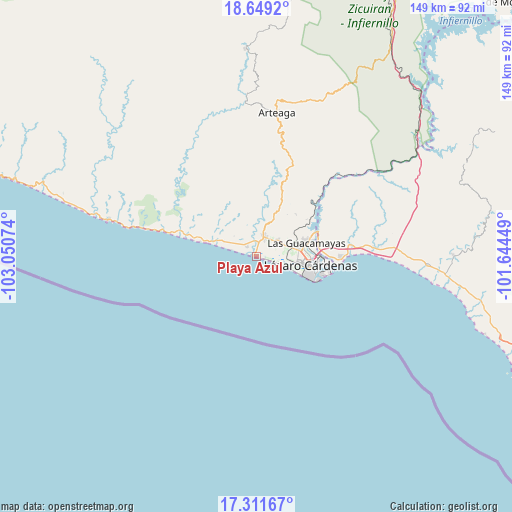
Playa Azul GPS coordinates[2]
17° 58' 54.12" North, 102° 20' 51.396" West
| Map corner | latitude | longitude |
|---|---|---|
| Upper-left | 18.6492°, | -103.05074° |
| Center: | 17.9817°, | -102.34761° |
| Lower-right: | 17.31167°, | -101.64449° |
| Map W x H: | 148.7×148.7 km | = 92.4×92.4mi |
| max Lat: | 32.7° ⇑78.9% North |
| Playa Azul: | 17.9817° |
| min Lat: | ⇓21.1% South 14.53588° |
| min Long | Playa Azul | max Long |
| -117.105° | -102.34761° | -86.73105° |
| W 16.8%⇐ | ⇒83.2% E |
Elevation
Elevation of Playa Azul is 9 m = 30 ft, and this is 1244.7 m = 4084 ft below average elevation for this country.
| Max E: |
3497 m = 11473 ft | 97.5% |
| Avg. | 1253.7 m = 4113 ft | |
| Playa Azul | 9 m = 30 ft | |
Min E: |
-1 m = -3 ft | 2.5% |
See also: Mexico elevation on elevation.city.
Geographical zone
Playa Azul is located in North Torrid zone (between Equator and Tropic of Cancer). Distance of this Northern Tropic circle is 606.5 km =376.9 mi to North.| Distance of | km | miles | from Playa Azul |
|---|---|---|---|
| North Pole | 8007.7 | 4975.8 | to North |
| Arctic Circle | 5401.8 | 3356.5 | to North |
| Tropic Cancer | 606.5 | 376.9 | to North |
| Equator | 1999.4 | 1242.4 | to South |


Nearby cities:
15 places around Playa Azul: (largest is in red/bold)
• Acalpican de Morelos
4.2 km =2.6 mi,  10°
10°
• Buenos Aires
8.1 km =5 mi,  53°
53°
• Chucutitán
13.5 km =8.4 mi,  290°
290°
• Ciudad Lázaro Cárdenas
13.4 km =8.3 mi,  95°
95°
• El Bordonal
4.6 km =2.9 mi, 54°
• El Habillal
3.9 km =2.4 mi,  316°
316°
• El Naranjito
20.1 km =12.5 mi,  88°
88°
• Guacamayas
14.9 km =9.3 mi,  73°
73°
• La Mira
6.2 km =3.9 mi,  21°
21°
• La Orilla
12.9 km =8 mi,  82°
82°
• Los Coyotes
16.6 km =10.3 mi, 24°
• Puente de la Vía
10.5 km =6.5 mi, 74°
• San Francisco
23 km =14.3 mi, 91°
• Tamacuas (El Ranchito)
18.8 km =11.7 mi, 72°
• Zacatula
18.1 km =11.2 mi, 80°
Sources, notices
• [Note1] Compared only with cities in Mexico existing in our database
• [Src1] Map data: © OpenStreetMap contributors (CC-BY-SA)
• [Src2] Other city data from geonames.org with taken over terms of usage.
• [Src3] Geographical zone / Annual Mean Temperature by Robert A. Rohde @ Wikipedia
