San Juanico Centro geodata
San Juanico Centro (State of Mexico) is a populated place; located in Mexico in America/Mexico_City (GMT-6) time zone. With population of 934 people, there are 9336 cities with bigger population in this country. Compared to other cities in Mexico, 54.1% of cities are located further ↓South; 64.4% of cities are located further →East and 93.5% of cities have lower elevation than San Juanico Centro. Note1


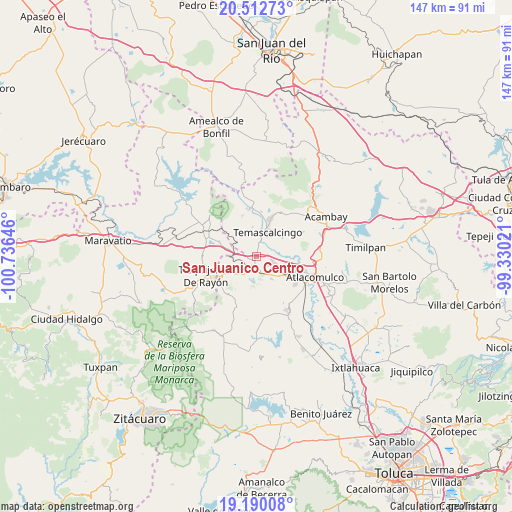
San Juanico Centro GPS coordinates[2]
19° 51' 10.008" North, 100° 1' 59.988" West
| Map corner | latitude | longitude |
|---|---|---|
| Upper-left | 20.51273°, | -100.73646° |
| Center: | 19.85278°, | -100.03333° |
| Lower-right: | 19.19008°, | -99.33021° |
| Map W x H: | 147.1×147.1 km | = 91.4×91.4mi |
| max Lat: | 32.7° ⇑45.9% North |
| San Juanico Centro: | 19.85278° |
| min Lat: | ⇓54.1% South 14.53588° |
| min Long | San Juanico Cen | max Long |
| -117.105° | -100.03333° | -86.73105° |
| W 35.6%⇐ | ⇒64.4% E |
Elevation
Elevation of San Juanico Centro is 2552 m = 8373 ft, and this is 1298.3 m = 4260 ft above average elevation for this country.
| Max E: |
3497 m = 11473 ft | 6.5% |
| San Juanico Centro | 2552 m 8373 ft | |
| Avg. | 1253.7 m = 4113 ft | |
Min E: |
-1 m = -3 ft | 93.5% |
See also: Mexico elevation on elevation.city.
Geographical zone
San Juanico Centro is located in North Torrid zone (between Equator and Tropic of Cancer). Distance of this Northern Tropic circle is 398.5 km =247.6 mi to North.| Distance of | km | miles | from San Juanico Centro |
|---|---|---|---|
| North Pole | 7799.6 | 4846.4 | to North |
| Arctic Circle | 5193.8 | 3227.3 | to North |
| Tropic Cancer | 398.5 | 247.6 | to North |
| Equator | 2207.4 | 1371.6 | to South |


Nearby cities:
15 places around San Juanico Centro: (largest is in red/bold)
• Adolfo López Mateos
6.7 km =4.2 mi,  149°
149°
• Barrio de Corona
7.3 km =4.5 mi,  37°
37°
• Buenavista
5.9 km =3.7 mi,  190°
190°
• Endotejiare
7.5 km =4.7 mi,  178°
178°
• La Huerta
6.9 km =4.3 mi,  3°
3°
• La Jordana
7.4 km =4.6 mi, 147°
• Los Pastores (Pastores Segundo Barrio)
5.4 km =3.4 mi,  85°
85°
• Mesa de Bañi
2.7 km =1.7 mi,  310°
310°
• Pastores Primer Barrio
4.7 km =2.9 mi, 85°
• Puruahua
7.9 km =4.9 mi, 35°
• San Francisco Tepeolulco
5.2 km =3.2 mi,  115°
115°
• Santa María Canchesdá
2.4 km =1.5 mi,  276°
276°
• Santiago Coachochitlan
1.1 km =0.7 mi,  353°
353°
• Temascalcingo
7.7 km =4.8 mi,  23°
23°
• Venta del Aire
2.3 km =1.4 mi,  218°
218°
Sources, notices
• [Note1] Compared only with cities in Mexico existing in our database
• [Src1] Map data: © OpenStreetMap contributors (CC-BY-SA)
• [Src2] Other city data from geonames.org with taken over terms of usage.
• [Src3] Geographical zone / Annual Mean Temperature by Robert A. Rohde @ Wikipedia
