Puruahua geodata
Puruahua (State of Mexico) is a populated place; located in Mexico in America/Mexico_City (GMT-6) time zone. With population of 556 people, there are 15345 cities with bigger population in this country. Compared to other cities in Mexico, 55.3% of cities are located further ↓South; 63.9% of cities are located further →East and 92.2% of cities have lower elevation than Puruahua. Note1


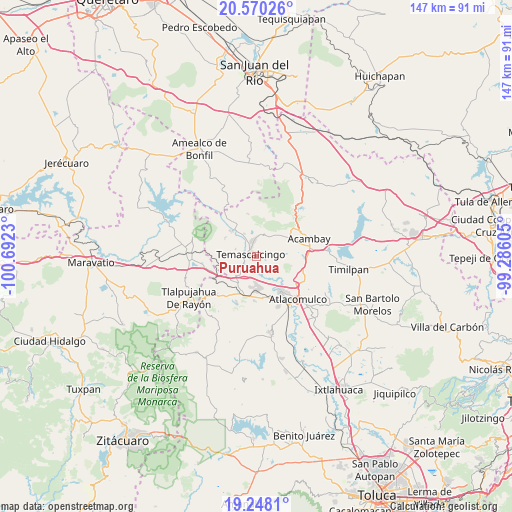
Puruahua GPS coordinates[2]
19° 54' 38.016" North, 99° 59' 21.012" West
| Map corner | latitude | longitude |
|---|---|---|
| Upper-left | 20.57026°, | -100.6923° |
| Center: | 19.91056°, | -99.98917° |
| Lower-right: | 19.2481°, | -99.28605° |
| Map W x H: | 147×147 km | = 91.3×91.3mi |
| max Lat: | 32.7° ⇑44.7% North |
| Puruahua: | 19.91056° |
| min Lat: | ⇓55.3% South 14.53588° |
| min Long | Puruahua | max Long |
| -117.105° | -99.98917° | -86.73105° |
| W 36.1%⇐ | ⇒63.9% E |
Elevation
Elevation of Puruahua is 2491 m = 8173 ft, and this is 1237.3 m = 4059 ft above average elevation for this country.
| Max E: |
3497 m = 11473 ft | 7.8% |
| Puruahua | 2491 m 8173 ft | |
| Avg. | 1253.7 m = 4113 ft | |
Min E: |
-1 m = -3 ft | 92.2% |
See also: Mexico elevation on elevation.city.
Geographical zone
Puruahua is located in North Torrid zone (between Equator and Tropic of Cancer). Distance of this Northern Tropic circle is 392.1 km =243.6 mi to North.| Distance of | km | miles | from Puruahua |
|---|---|---|---|
| North Pole | 7793.2 | 4842.5 | to North |
| Arctic Circle | 5187.3 | 3223.2 | to North |
| Tropic Cancer | 392.1 | 243.6 | to North |
| Equator | 2213.8 | 1375.6 | to South |


Nearby cities:
15 places around Puruahua: (largest is in red/bold)
• Ahuacatitlan Centro
4.8 km =3 mi,  358°
358°
• Ahuacatitlán Cuarto y Quinto Cuartel
5.7 km =3.5 mi,  2°
2°
• Barrio de Corona
0.6 km =0.4 mi,  199°
199°
• Cerritos de Cárdenas
7.4 km =4.6 mi,  331°
331°
• Doxteje Barrio Primero
6.3 km =3.9 mi,  30°
30°
• Doxtejé Centro
7.6 km =4.7 mi, 29°
• La Huerta
4.2 km =2.6 mi,  276°
276°
• La Magdalena
4.3 km =2.7 mi,  345°
345°
• Los Pastores (Pastores Segundo Barrio)
6.1 km =3.8 mi,  172°
172°
• Pastores Primer Barrio
6 km =3.7 mi,  179°
179°
• San Francisco Solis
6.2 km =3.9 mi,  290°
290°
• San José Toxi
7.2 km =4.5 mi,  131°
131°
• San Pedro el Alto
2.7 km =1.7 mi,  90°
90°
• Santiago Coachochitlan
7.1 km =4.4 mi,  221°
221°
• Temascalcingo
1.6 km =1 mi, 292°
Sources, notices
• [Note1] Compared only with cities in Mexico existing in our database
• [Src1] Map data: © OpenStreetMap contributors (CC-BY-SA)
• [Src2] Other city data from geonames.org with taken over terms of usage.
• [Src3] Geographical zone / Annual Mean Temperature by Robert A. Rohde @ Wikipedia
