La Piedra geodata
La Piedra (State of Mexico) is a populated place; located in Mexico in America/Mexico_City (GMT-6) time zone. With population of 613 people, there are 14065 cities with bigger population in this country. Compared to other cities in Mexico, 55% of cities are located further ↑North; 66.1% of cities are located further →East and 99.6% of cities have lower elevation than La Piedra. Note1


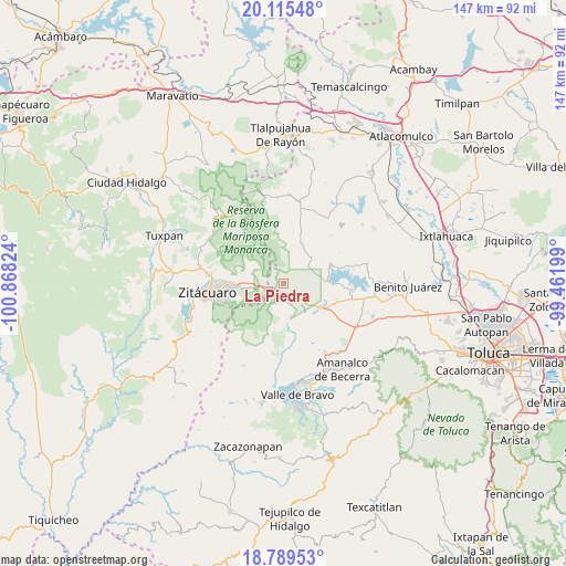
La Piedra GPS coordinates[2]
19° 27' 13.896" North, 100° 9' 54.396" West
| Map corner | latitude | longitude |
|---|---|---|
| Upper-left | 20.11548°, | -100.86824° |
| Center: | 19.45386°, | -100.16511° |
| Lower-right: | 18.78953°, | -99.46199° |
| Map W x H: | 147.4×147.4 km | = 91.6×91.6mi |
| max Lat: | 32.7° ⇑55% North |
| La Piedra: | 19.45386° |
| min Lat: | ⇓45% South 14.53588° |
| min Long | La Piedra | max Long |
| -117.105° | -100.16511° | -86.73105° |
| W 33.9%⇐ | ⇒66.1% E |
Elevation
Elevation of La Piedra is 2923 m = 9590 ft, and this is 1669.3 m = 5477 ft above average elevation for this country.
| Max E: |
3497 m = 11473 ft | 0.40000000000001% |
| La Piedra | 2923 m 9590 ft | |
| Avg. | 1253.7 m = 4113 ft | |
Min E: |
-1 m = -3 ft | 99.6% |
See also: Mexico elevation on elevation.city.
Geographical zone
La Piedra is located in North Torrid zone (between Equator and Tropic of Cancer). Distance of this Northern Tropic circle is 442.9 km =275.2 mi to North.| Distance of | km | miles | from La Piedra |
|---|---|---|---|
| North Pole | 7844 | 4874 | to North |
| Arctic Circle | 5238.1 | 3254.8 | to North |
| Tropic Cancer | 442.9 | 275.2 | to North |
| Equator | 2163.1 | 1344.1 | to South |


Nearby cities:
15 places around La Piedra: (largest is in red/bold)
• Barrio Puentecillas el Depósito
6.9 km =4.3 mi,  358°
358°
• Barrio el Boncho
6.9 km =4.3 mi,  116°
116°
• Barrio la Joya
7.8 km =4.8 mi, 118°
• El Tigre (Segunda Manzana de Crescencio Morales)
8.6 km =5.3 mi,  284°
284°
• Loma de Juárez
8.1 km =5 mi,  104°
104°
• Loma de San Pablo
6.8 km =4.2 mi,  190°
190°
• Loma del Cedro
6.2 km =3.9 mi,  10°
10°
• Macho de Agua
8.1 km =5 mi,  260°
260°
• Mesa de Suchitímber
6.1 km =3.8 mi,  81°
81°
• Palizada
8.9 km =5.5 mi,  49°
49°
• San Francisco de Asís
6.3 km =3.9 mi,  135°
135°
• San José Villa de Allende
8.9 km =5.5 mi,  168°
168°
• San Pablo Malacatepec
9.1 km =5.7 mi, 174°
• Santa María
6.1 km =3.8 mi, 172°
• Santa Teresa
8 km =5 mi, 194°
Sources, notices
• [Note1] Compared only with cities in Mexico existing in our database
• [Src1] Map data: © OpenStreetMap contributors (CC-BY-SA)
• [Src2] Other city data from geonames.org with taken over terms of usage.
• [Src3] Geographical zone / Annual Mean Temperature by Robert A. Rohde @ Wikipedia
