Barrio el Boncho geodata
Barrio el Boncho (State of Mexico) is a populated place; located in Mexico in America/Mexico_City (GMT-6) time zone. With population of 1,114 people, there are 7797 cities with bigger population in this country. Compared to other cities in Mexico, 55.6% of cities are located further ↑North; 65.2% of cities are located further →East and 96.1% of cities have lower elevation than Barrio el Boncho. Note1


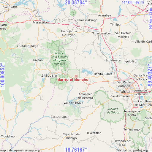
Barrio el Boncho GPS coordinates[2]
19° 25' 33.996" North, 100° 6' 23.004" West
| Map corner | latitude | longitude |
|---|---|---|
| Upper-left | 20.08784°, | -100.80952° |
| Center: | 19.42611°, | -100.10639° |
| Lower-right: | 18.76167°, | -99.40327° |
| Map W x H: | 147.5×147.5 km | = 91.7×91.7mi |
| max Lat: | 32.7° ⇑55.6% North |
| Barrio el Boncho: | 19.42611° |
| min Lat: | ⇓44.4% South 14.53588° |
| min Long | Barrio el Bonch | max Long |
| -117.105° | -100.10639° | -86.73105° |
| W 34.8%⇐ | ⇒65.2% E |
Elevation
Elevation of Barrio el Boncho is 2631 m = 8632 ft, and this is 1377.3 m = 4519 ft above average elevation for this country.
| Max E: |
3497 m = 11473 ft | 3.9% |
| Barrio el Boncho | 2631 m 8632 ft | |
| Avg. | 1253.7 m = 4113 ft | |
Min E: |
-1 m = -3 ft | 96.1% |
See also: Mexico elevation on elevation.city.
Geographical zone
Barrio el Boncho is located in North Torrid zone (between Equator and Tropic of Cancer). Distance of this Northern Tropic circle is 445.9 km =277.1 mi to North.| Distance of | km | miles | from Barrio el Boncho |
|---|---|---|---|
| North Pole | 7847.1 | 4876 | to North |
| Arctic Circle | 5241.2 | 3256.7 | to North |
| Tropic Cancer | 445.9 | 277.1 | to North |
| Equator | 2160 | 1342.2 | to South |


Nearby cities:
15 places around Barrio el Boncho: (largest is in red/bold)
• Barrio la Joya
1 km =0.6 mi,  134°
134°
• Barrio los Tules
3.3 km =2.1 mi,  84°
84°
• Cabecera de Indígenas
6.8 km =4.2 mi,  207°
207°
• Dolores Vaquerías
6.3 km =3.9 mi,  104°
104°
• El Espinal
6.7 km =4.2 mi,  46°
46°
• El Jacal
2.9 km =1.8 mi,  142°
142°
• La Piedra
6.9 km =4.3 mi,  296°
296°
• Loma de Juárez
2 km =1.2 mi,  59°
59°
• Los Berros
6.9 km =4.3 mi,  117°
117°
• Mesa de Suchitímber
4 km =2.5 mi,  358°
358°
• San Cayetano
5.5 km =3.4 mi,  172°
172°
• San Felipe Santiago
4 km =2.5 mi,  180°
180°
• San Francisco de Asís
2.3 km =1.4 mi,  231°
231°
• San Isidro
4 km =2.5 mi,  159°
159°
• Santa María
6.1 km =3.8 mi,  241°
241°
Sources, notices
• [Note1] Compared only with cities in Mexico existing in our database
• [Src1] Map data: © OpenStreetMap contributors (CC-BY-SA)
• [Src2] Other city data from geonames.org with taken over terms of usage.
• [Src3] Geographical zone / Annual Mean Temperature by Robert A. Rohde @ Wikipedia
