La Bajada geodata
La Bajada (Guerrero) is a populated place; located in Mexico in America/Mexico_City (GMT-6) time zone. With population of 593 people, there are 14492 cities with bigger population in this country. Compared to other cities in Mexico, 74.7% of cities are located further ↑North; 70.9% of cities are located further →East and 74% of cities have higher elevation than La Bajada. Note1


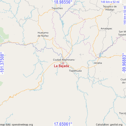
La Bajada GPS coordinates[2]
18° 19' 9.732" North, 100° 40' 19.02" West
| Map corner | latitude | longitude |
|---|---|---|
| Upper-left | 18.98556°, | -101.37508° |
| Center: | 18.31937°, | -100.67195° |
| Lower-right: | 17.65061°, | -99.96883° |
| Map W x H: | 148.4×148.4 km | = 92.2×92.2mi |
| max Lat: | 32.7° ⇑74.7% North |
| La Bajada: | 18.31937° |
| min Lat: | ⇓25.3% South 14.53588° |
| min Long | La Bajada | max Long |
| -117.105° | -100.67195° | -86.73105° |
| W 29.1%⇐ | ⇒70.9% E |
Elevation
Elevation of La Bajada is 254 m = 833 ft, and this is 999.7 m = 3280 ft below average elevation for this country.
| Max E: |
3497 m = 11473 ft | 74% |
| Avg. | 1253.7 m = 4113 ft | |
| La Bajada | 254 m = 833 ft | |
Min E: |
-1 m = -3 ft | 26% |
See also: Mexico elevation on elevation.city.
Geographical zone
La Bajada is located in North Torrid zone (between Equator and Tropic of Cancer). Distance of this Northern Tropic circle is 569 km =353.6 mi to North.| Distance of | km | miles | from La Bajada |
|---|---|---|---|
| North Pole | 7970.1 | 4952.4 | to North |
| Arctic Circle | 5364.3 | 3333.2 | to North |
| Tropic Cancer | 569 | 353.6 | to North |
| Equator | 2036.9 | 1265.7 | to South |


Nearby cities:
15 places around La Bajada: (largest is in red/bold)
• Amuco de la Reforma
4.4 km =2.7 mi,  130°
130°
• Ciudad Altamirano
4.3 km =2.7 mi,  3°
3°
• Coyuca de Catalán
3 km =1.9 mi,  284°
284°
• El Coco
5.3 km =3.3 mi,  231°
231°
• Las Tinajas
5.8 km =3.6 mi,  318°
318°
• Los Limones
5.5 km =3.4 mi,  49°
49°
• Querendas
4.7 km =2.9 mi,  56°
56°
• Río Florido (Las Ánimas)
7.7 km =4.8 mi,  336°
336°
• San Jerónimo
6.8 km =4.2 mi, 0°
• San Juan Chámacua
5.8 km =3.6 mi,  189°
189°
• San Juan de la Cruz
5.9 km =3.7 mi,  177°
177°
• Santa Bárbara
3.6 km =2.2 mi,  69°
69°
• Santa Cruz de Villa Gómez
7.6 km =4.7 mi,  34°
34°
• Tanganhuato
7.4 km =4.6 mi,  120°
120°
• Tierra Blanca
2.3 km =1.4 mi,  308°
308°
Sources, notices
• [Note1] Compared only with cities in Mexico existing in our database
• [Src1] Map data: © OpenStreetMap contributors (CC-BY-SA)
• [Src2] Other city data from geonames.org with taken over terms of usage.
• [Src3] Geographical zone / Annual Mean Temperature by Robert A. Rohde @ Wikipedia
