San Juan Chámacua geodata
San Juan Chámacua (Guerrero) is a populated place; located in Mexico in America/Mexico_City (GMT-6) time zone. With population of 673 people, there are 12911 cities with bigger population in this country. Compared to other cities in Mexico, 75.3% of cities are located further ↑North; 70.9% of cities are located further →East and 73.4% of cities have higher elevation than San Juan Chámacua. Note1


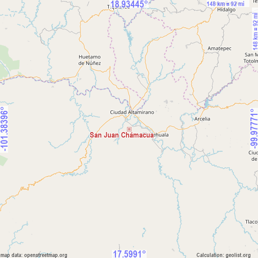
San Juan Chámacua GPS coordinates[2]
18° 16' 5.016" North, 100° 40' 50.988" West
| Map corner | latitude | longitude |
|---|---|---|
| Upper-left | 18.93445°, | -101.38396° |
| Center: | 18.26806°, | -100.68083° |
| Lower-right: | 17.5991°, | -99.97771° |
| Map W x H: | 148.5×148.5 km | = 92.3×92.3mi |
| max Lat: | 32.7° ⇑75.3% North |
| San Juan Chámacua: | 18.26806° |
| min Lat: | ⇓24.7% South 14.53588° |
| min Long | San Juan Cháma | max Long |
| -117.105° | -100.68083° | -86.73105° |
| W 29.1%⇐ | ⇒70.9% E |
Elevation
Elevation of San Juan Chámacua is 274 m = 899 ft, and this is 979.7 m = 3214 ft below average elevation for this country.
| Max E: |
3497 m = 11473 ft | 73.4% |
| Avg. | 1253.7 m = 4113 ft | |
| San Juan Chámacua | 274 m = 899 ft | |
Min E: |
-1 m = -3 ft | 26.6% |
See also: Mexico elevation on elevation.city.
Geographical zone
San Juan Chámacua is located in North Torrid zone (between Equator and Tropic of Cancer). Distance of this Northern Tropic circle is 574.7 km =357.1 mi to North.| Distance of | km | miles | from San Juan Chámacua |
|---|---|---|---|
| North Pole | 7975.8 | 4955.9 | to North |
| Arctic Circle | 5370 | 3336.8 | to North |
| Tropic Cancer | 574.7 | 357.1 | to North |
| Equator | 2031.2 | 1262.1 | to South |


Nearby cities:
15 places around San Juan Chámacua: (largest is in red/bold)
• Amuco de la Reforma
5.2 km =3.2 mi,  56°
56°
• Changata
10.1 km =6.3 mi,  86°
86°
• Ciudad Altamirano
10.1 km =6.3 mi,  6°
6°
• Coyuca de Catalán
6.7 km =4.2 mi,  343°
343°
• El Coco
4 km =2.5 mi,  306°
306°
• Jaripo
10.1 km =6.3 mi,  315°
315°
• La Bajada
5.8 km =3.6 mi, 9°
• Las Cruces
10.2 km =6.3 mi,  256°
256°
• Querendas
9.6 km =6 mi,  30°
30°
• San Juan de la Cruz
1.2 km =0.7 mi,  98°
98°
• San Lorenzo
7.4 km =4.6 mi, 85°
• Santa Bárbara
8.2 km =5.1 mi, 31°
• Sinahua
8.6 km =5.3 mi,  80°
80°
• Tanganhuato
7.6 km =4.7 mi,  74°
74°
• Tierra Blanca
7.2 km =4.5 mi,  352°
352°
Sources, notices
• [Note1] Compared only with cities in Mexico existing in our database
• [Src1] Map data: © OpenStreetMap contributors (CC-BY-SA)
• [Src2] Other city data from geonames.org with taken over terms of usage.
• [Src3] Geographical zone / Annual Mean Temperature by Robert A. Rohde @ Wikipedia
