Los Mogotes geodata
Los Mogotes (Guerrero) is a populated place; located in Mexico in America/Mexico_City (GMT-6) time zone. With population of 1,284 people, there are 6748 cities with bigger population in this country. Compared to other cities in Mexico, 89.7% of cities are located further ↑North; 64.9% of cities are located further →East and 96.3% of cities have higher elevation than Los Mogotes. Note1


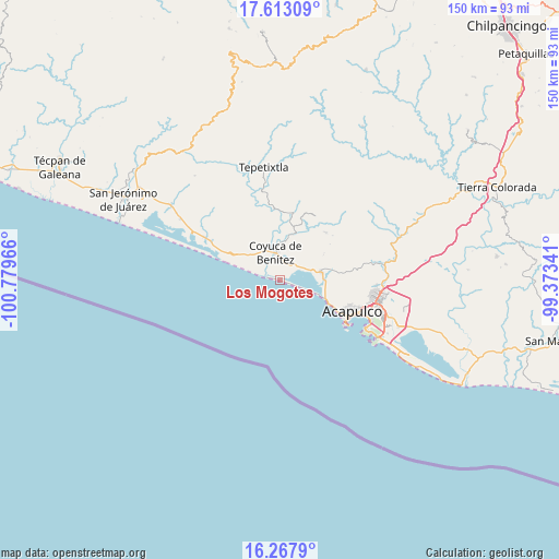
Los Mogotes GPS coordinates[2]
16° 56' 30.12" North, 100° 4' 35.508" West
| Map corner | latitude | longitude |
|---|---|---|
| Upper-left | 17.61309°, | -100.77966° |
| Center: | 16.9417°, | -100.07653° |
| Lower-right: | 16.2679°, | -99.37341° |
| Map W x H: | 149.6×149.6 km | = 93×93mi |
| max Lat: | 32.7° ⇑89.7% North |
| Los Mogotes: | 16.9417° |
| min Lat: | ⇓10.3% South 14.53588° |
| min Long | Los Mogotes | max Long |
| -117.105° | -100.07653° | -86.73105° |
| W 35.1%⇐ | ⇒64.9% E |
Elevation
Elevation of Los Mogotes is 11 m = 36 ft, and this is 1242.7 m = 4077 ft below average elevation for this country.
| Max E: |
3497 m = 11473 ft | 96.3% |
| Avg. | 1253.7 m = 4113 ft | |
| Los Mogotes | 11 m = 36 ft | |
Min E: |
-1 m = -3 ft | 3.7% |
See also: Mexico elevation on elevation.city.
Geographical zone
Los Mogotes is located in North Torrid zone (between Equator and Tropic of Cancer). Distance of this Northern Tropic circle is 722.2 km =448.8 mi to North.| Distance of | km | miles | from Los Mogotes |
|---|---|---|---|
| North Pole | 8123.3 | 5047.6 | to North |
| Arctic Circle | 5517.4 | 3428.4 | to North |
| Tropic Cancer | 722.2 | 448.8 | to North |
| Equator | 1883.7 | 1170.5 | to South |


Nearby cities:
15 places around Los Mogotes: (largest is in red/bold)
• Aguas Blancas
10.6 km =6.6 mi,  7°
7°
• Bajos del Ejido
11.4 km =7.1 mi,  79°
79°
• Colonia Luces en el Mar
6.9 km =4.3 mi,  108°
108°
• Colonia Lázaro Cárdenas
6.2 km =3.9 mi,  346°
346°
• Coyuca de Benítez
7.6 km =4.7 mi, 351°
• El Bejuco
4.6 km =2.9 mi,  321°
321°
• El Bordonal
7.1 km =4.4 mi,  60°
60°
• El Embarcadero
8.3 km =5.2 mi,  72°
72°
• El Espinalillo
7.2 km =4.5 mi,  311°
311°
• La Barra
3.4 km =2.1 mi,  281°
281°
• Las Lomas
4.9 km =3 mi,  336°
336°
• Playa del Carrizal
7.4 km =4.6 mi,  288°
288°
• Pénjamo
9.1 km =5.7 mi,  333°
333°
• San Nicolás
6.7 km =4.2 mi, 305°
• Yetla
9.7 km =6 mi,  53°
53°
Sources, notices
• [Note1] Compared only with cities in Mexico existing in our database
• [Src1] Map data: © OpenStreetMap contributors (CC-BY-SA)
• [Src2] Other city data from geonames.org with taken over terms of usage.
• [Src3] Geographical zone / Annual Mean Temperature by Robert A. Rohde @ Wikipedia
