San Pedro Mártir geodata
San Pedro Mártir (Querétaro) is a populated place; located in Mexico in America/Mexico_City (GMT-6) time zone. With population of 11,552 people, there are 830 cities with bigger population in this country. Compared to other cities in Mexico, 70.3% of cities are located further ↓South; 69.2% of cities are located further →East and 64.8% of cities have lower elevation than San Pedro Mártir. Note1


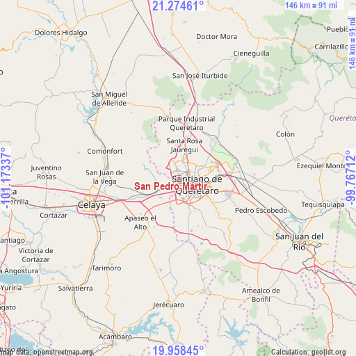
San Pedro Mártir GPS coordinates[2]
20° 37' 4.62" North, 100° 28' 12.864" West
| Map corner | latitude | longitude |
|---|---|---|
| Upper-left | 21.27461°, | -101.17337° |
| Center: | 20.61795°, | -100.47024° |
| Lower-right: | 19.95845°, | -99.76712° |
| Map W x H: | 146.3×146.3 km | = 90.9×90.9mi |
| max Lat: | 32.7° ⇑29.7% North |
| San Pedro Mártir: | 20.61795° |
| min Lat: | ⇓70.3% South 14.53588° |
| min Long | San Pedro Márt | max Long |
| -117.105° | -100.47024° | -86.73105° |
| W 30.8%⇐ | ⇒69.2% E |
Elevation
Elevation of San Pedro Mártir is 1823 m = 5981 ft, and this is 569.3 m = 1868 ft above average elevation for this country.
| Max E: |
3497 m = 11473 ft | 35.2% |
| San Pedro Mártir | 1823 m 5981 ft | |
| Avg. | 1253.7 m = 4113 ft | |
Min E: |
-1 m = -3 ft | 64.8% |
See also: Mexico elevation on elevation.city.
Geographical zone
San Pedro Mártir is located in North Torrid zone (between Equator and Tropic of Cancer). Distance of this Northern Tropic circle is 313.4 km =194.7 mi to North.| Distance of | km | miles | from San Pedro Mártir |
|---|---|---|---|
| North Pole | 7714.6 | 4793.6 | to North |
| Arctic Circle | 5108.7 | 3174.4 | to North |
| Tropic Cancer | 313.4 | 194.7 | to North |
| Equator | 2292.5 | 1424.5 | to South |


Nearby cities:
15 places around San Pedro Mártir: (largest is in red/bold)
• Bosques de la Hacienda
6.7 km =4.2 mi,  55°
55°
• Colinas de Santa Cruz Segunda Sección
0.7 km =0.4 mi,  30°
30°
• El Castillo
4.8 km =3 mi,  209°
209°
• El Salitre
7.3 km =4.5 mi,  42°
42°
• El Zapote
7.8 km =4.8 mi,  298°
298°
• Huertas la Joya [Fraccionamiento Campestre]
3.4 km =2.1 mi,  279°
279°
• Jardines de Azucenas (La Floresta)
2 km =1.2 mi,  323°
323°
• Patria Nueva
1.7 km =1.1 mi,  336°
336°
• Praga
7.1 km =4.4 mi, 322°
• Rancho Bellavista [Fraccionamiento]
2.5 km =1.6 mi,  120°
120°
• San Francisco de la Palma
6.6 km =4.1 mi, 315°
• Santa María Magdalena
3.3 km =2.1 mi,  134°
134°
• Sergio Villaseñor
6 km =3.7 mi, 59°
• Tlacote el Bajo
6.2 km =3.9 mi, 321°
• Tonatiú
2.1 km =1.3 mi,  108°
108°
Sources, notices
• [Note1] Compared only with cities in Mexico existing in our database
• [Src1] Map data: © OpenStreetMap contributors (CC-BY-SA)
• [Src2] Other city data from geonames.org with taken over terms of usage.
• [Src3] Geographical zone / Annual Mean Temperature by Robert A. Rohde @ Wikipedia
