Sergio Villaseñor geodata
Sergio Villaseñor (Querétaro) is a populated place; located in Mexico in America/Mexico_City (GMT-6) time zone. With population of 1,238 people, there are 7007 cities with bigger population in this country. Compared to other cities in Mexico, 70.8% of cities are located further ↓South; 68.7% of cities are located further →East and 72.1% of cities have lower elevation than Sergio Villaseñor. Note1


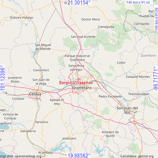
Sergio Villaseñor GPS coordinates[2]
20° 38' 42" North, 100° 25' 14.988" West
| Map corner | latitude | longitude |
|---|---|---|
| Upper-left | 21.30154°, | -101.12396° |
| Center: | 20.645°, | -100.42083° |
| Lower-right: | 19.98562°, | -99.71771° |
| Map W x H: | 146.3×146.3 km | = 90.9×90.9mi |
| max Lat: | 32.7° ⇑29.2% North |
| Sergio Villaseñor: | 20.645° |
| min Lat: | ⇓70.8% South 14.53588° |
| min Long | Sergio Villase� | max Long |
| -117.105° | -100.42083° | -86.73105° |
| W 31.3%⇐ | ⇒68.7% E |
Elevation
Elevation of Sergio Villaseñor is 1969 m = 6460 ft, and this is 715.3 m = 2347 ft above average elevation for this country.
| Max E: |
3497 m = 11473 ft | 27.9% |
| Sergio Villaseñor | 1969 m 6460 ft | |
| Avg. | 1253.7 m = 4113 ft | |
Min E: |
-1 m = -3 ft | 72.1% |
See also: Mexico elevation on elevation.city.
Geographical zone
Sergio Villaseñor is located in North Torrid zone (between Equator and Tropic of Cancer). Distance of this Northern Tropic circle is 310.4 km =192.9 mi to North.| Distance of | km | miles | from Sergio Villaseñor |
|---|---|---|---|
| North Pole | 7711.6 | 4791.8 | to North |
| Arctic Circle | 5105.7 | 3172.5 | to North |
| Tropic Cancer | 310.4 | 192.9 | to North |
| Equator | 2295.5 | 1426.4 | to South |


Nearby cities:
15 places around Sergio Villaseñor: (largest is in red/bold)
• Bosques de la Hacienda
0.9 km =0.6 mi,  29°
29°
• Colinas de Santa Cruz Segunda Sección
5.3 km =3.3 mi,  243°
243°
• Ejido San Pablo
2.4 km =1.5 mi,  18°
18°
• El Salitre
2.3 km =1.4 mi,  354°
354°
• Fray Junípero Serra [Fraccionamiento]
5.5 km =3.4 mi,  72°
72°
• Jardines de Azucenas (La Floresta)
6.5 km =4 mi,  257°
257°
• Lomas de Menchaca
3.9 km =2.4 mi,  102°
102°
• Paseos del Pedregal
3.2 km =2 mi,  48°
48°
• Patria Nueva
6 km =3.7 mi, 256°
• Rancho Bellavista [Fraccionamiento]
5.2 km =3.2 mi,  215°
215°
• San José el Alto
4.1 km =2.5 mi,  76°
76°
• San Pedro Mártir
6 km =3.7 mi, 239°
• Santa María Magdalena
6 km =3.7 mi,  207°
207°
• Tonatiú
4.8 km =3 mi, 220°
• Villas Fontana [Fraccionamiento]
2.1 km =1.3 mi,  41°
41°
Sources, notices
• [Note1] Compared only with cities in Mexico existing in our database
• [Src1] Map data: © OpenStreetMap contributors (CC-BY-SA)
• [Src2] Other city data from geonames.org with taken over terms of usage.
• [Src3] Geographical zone / Annual Mean Temperature by Robert A. Rohde @ Wikipedia
