La Aldea geodata
La Aldea (Michoacán) is a populated place; located in Mexico in America/Mexico_City (GMT-6) time zone. With population of 6,162 people, there are 1518 cities with bigger population in this country. Compared to other cities in Mexico, 51.4% of cities are located further ↓South; 74.5% of cities are located further →East and 69% of cities have lower elevation than La Aldea. Note1


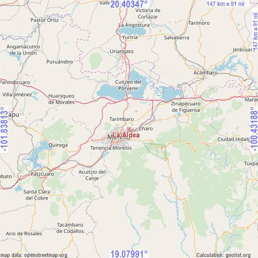
La Aldea GPS coordinates[2]
19° 44' 35.016" North, 101° 8' 6" West
| Map corner | latitude | longitude |
|---|---|---|
| Upper-left | 20.40347°, | -101.83813° |
| Center: | 19.74306°, | -101.135° |
| Lower-right: | 19.07991°, | -100.43188° |
| Map W x H: | 147.2×147.2 km | = 91.5×91.5mi |
| max Lat: | 32.7° ⇑48.6% North |
| La Aldea: | 19.74306° |
| min Lat: | ⇓51.4% South 14.53588° |
| min Long | La Aldea | max Long |
| -117.105° | -101.135° | -86.73105° |
| W 25.5%⇐ | ⇒74.5% E |
Elevation
Elevation of La Aldea is 1908 m = 6260 ft, and this is 654.3 m = 2147 ft above average elevation for this country.
| Max E: |
3497 m = 11473 ft | 31% |
| La Aldea | 1908 m 6260 ft | |
| Avg. | 1253.7 m = 4113 ft | |
Min E: |
-1 m = -3 ft | 69% |
See also: Mexico elevation on elevation.city.
Geographical zone
La Aldea is located in North Torrid zone (between Equator and Tropic of Cancer). Distance of this Northern Tropic circle is 410.7 km =255.2 mi to North.| Distance of | km | miles | from La Aldea |
|---|---|---|---|
| North Pole | 7811.8 | 4854 | to North |
| Arctic Circle | 5206 | 3234.9 | to North |
| Tropic Cancer | 410.7 | 255.2 | to North |
| Equator | 2195.2 | 1364 | to South |


Nearby cities:
15 places around La Aldea: (largest is in red/bold)
• Atapaneo
2.1 km =1.3 mi,  102°
102°
• Campestre Tarímbaro
3.6 km =2.2 mi,  9°
9°
• Cañadas del Bosque
4.6 km =2.9 mi,  112°
112°
• Colonia José Vasconcelos
3.4 km =2.1 mi,  54°
54°
• Colonia Verónica López
2.5 km =1.6 mi,  333°
333°
• Conjunto Habitacional el Trébol
3.4 km =2.1 mi,  322°
322°
• El Cuitzillo Grande
4.5 km =2.8 mi,  24°
24°
• Fraccionamiento Laureles Eréndira
3.3 km =2.1 mi, 8°
• Fraccionamiento Misión del Valle
2.9 km =1.8 mi,  29°
29°
• Fraccionamiento la Cantera
4 km =2.5 mi, 315°
• Francisco Villa
3.6 km =2.2 mi,  286°
286°
• La Palma (Las Palmas)
3.2 km =2 mi,  348°
348°
• San Bernabé de las Canteras
3.9 km =2.4 mi,  311°
311°
• San José de la Trinidad
4.1 km =2.5 mi, 323°
• Terranova
3.8 km =2.4 mi, 5°
Sources, notices
• [Note1] Compared only with cities in Mexico existing in our database
• [Src1] Map data: © OpenStreetMap contributors (CC-BY-SA)
• [Src2] Other city data from geonames.org with taken over terms of usage.
• [Src3] Geographical zone / Annual Mean Temperature by Robert A. Rohde @ Wikipedia
