El Cuitzillo Grande geodata
El Cuitzillo Grande (Michoacán) is a populated place; located in Mexico in America/Mexico_City (GMT-6) time zone. With population of 1,130 people, there are 7675 cities with bigger population in this country. Compared to other cities in Mexico, 52.3% of cities are located further ↓South; 74.4% of cities are located further →East and 66.4% of cities have lower elevation than El Cuitzillo Grande. Note1


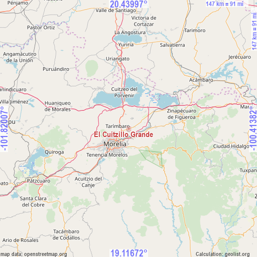
El Cuitzillo Grande GPS coordinates[2]
19° 46' 46.992" North, 101° 7' 0.984" West
| Map corner | latitude | longitude |
|---|---|---|
| Upper-left | 20.43997°, | -101.82007° |
| Center: | 19.77972°, | -101.11694° |
| Lower-right: | 19.11672°, | -100.41382° |
| Map W x H: | 147.1×147.1 km | = 91.4×91.4mi |
| max Lat: | 32.7° ⇑47.7% North |
| El Cuitzillo Grande: | 19.77972° |
| min Lat: | ⇓52.3% South 14.53588° |
| min Long | El Cuitzillo Gr | max Long |
| -117.105° | -101.11694° | -86.73105° |
| W 25.6%⇐ | ⇒74.4% E |
Elevation
Elevation of El Cuitzillo Grande is 1858 m = 6096 ft, and this is 604.3 m = 1983 ft above average elevation for this country.
| Max E: |
3497 m = 11473 ft | 33.6% |
| El Cuitzillo Grande | 1858 m 6096 ft | |
| Avg. | 1253.7 m = 4113 ft | |
Min E: |
-1 m = -3 ft | 66.4% |
See also: Mexico elevation on elevation.city.
Geographical zone
El Cuitzillo Grande is located in North Torrid zone (between Equator and Tropic of Cancer). Distance of this Northern Tropic circle is 406.6 km =252.6 mi to North.| Distance of | km | miles | from El Cuitzillo Grande |
|---|---|---|---|
| North Pole | 7807.8 | 4851.5 | to North |
| Arctic Circle | 5201.9 | 3232.3 | to North |
| Tropic Cancer | 406.6 | 252.6 | to North |
| Equator | 2199.3 | 1366.6 | to South |


Nearby cities:
15 places around El Cuitzillo Grande: (largest is in red/bold)
• Atapaneo
4.5 km =2.8 mi,  178°
178°
• Campestre Tarímbaro
1.4 km =0.9 mi,  247°
247°
• Colonia José Vasconcelos
2.3 km =1.4 mi,  157°
157°
• Colonia Miguel Hidalgo
1.8 km =1.1 mi,  67°
67°
• Colonia Verónica López
3.5 km =2.2 mi,  237°
237°
• Conjunto Habitacional el Trébol
4.2 km =2.6 mi, 250°
• Fraccionamiento Laureles Eréndira
1.7 km =1.1 mi, 239°
• Fraccionamiento Misión del Valle
1.7 km =1.1 mi,  197°
197°
• Fraccionamiento la Cantera
4.9 km =3 mi,  256°
256°
• La Aldea
4.5 km =2.8 mi, 204°
• La Palma (Las Palmas)
2.7 km =1.7 mi, 249°
• San José de la Trinidad
4.4 km =2.7 mi, 259°
• San Pedro de los Sauces
2.3 km =1.4 mi,  288°
288°
• Terranova
1.6 km =1 mi, 259°
• Uruétaro
3.3 km =2.1 mi, 68°
Sources, notices
• [Note1] Compared only with cities in Mexico existing in our database
• [Src1] Map data: © OpenStreetMap contributors (CC-BY-SA)
• [Src2] Other city data from geonames.org with taken over terms of usage.
• [Src3] Geographical zone / Annual Mean Temperature by Robert A. Rohde @ Wikipedia
