Rancho Verde geodata
Rancho Verde (Baja California) is a populated place; located in Mexico in America/Tijuana (GMT-7) time zone. With population of 2,758 people, there are 3208 cities with bigger population in this country. Compared to other cities in Mexico, 99.3% of cities are located further ↓South; 99.7% of cities are located further →East and 80.9% of cities have higher elevation than Rancho Verde. Note1


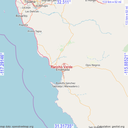
Rancho Verde GPS coordinates[2]
31° 54' 57.996" North, 116° 35' 17.988" West
| Map corner | latitude | longitude |
|---|---|---|
| Upper-left | 32.511°, | -117.29146° |
| Center: | 31.91611°, | -116.58833° |
| Lower-right: | 31.31735°, | -115.88521° |
| Map W x H: | 132.7×132.7 km | = 82.5×82.5mi |
| max Lat: | 32.7° ⇑0.7% North |
| Rancho Verde: | 31.91611° |
| min Lat: | ⇓99.3% South 14.53588° |
| min Long | Rancho Verde | max Long |
| -117.105° | -116.58833° | -86.73105° |
| W 0.3%⇐ | ⇒99.7% E |
Elevation
Elevation of Rancho Verde is 84 m = 276 ft, and this is 1169.7 m = 3838 ft below average elevation for this country.
| Max E: |
3497 m = 11473 ft | 80.9% |
| Avg. | 1253.7 m = 4113 ft | |
| Rancho Verde | 84 m = 276 ft | |
Min E: |
-1 m = -3 ft | 19.1% |
See also: Mexico elevation on elevation.city.
Geographical zone
Rancho Verde is located in North temperate zone (between Tropic of Cancer and the Arctic Circle). Distance of this Northern Tropic circle is 942.8 km =585.8 mi to South.| Distance of | km | miles | from Rancho Verde |
|---|---|---|---|
| North Pole | 6458.3 | 4013 | to North |
| Arctic Circle | 3852.4 | 2393.8 | to North |
| Tropic Cancer | 942.8 | 585.8 | to South |
| Equator | 3548.7 | 2205.1 | to South |


Nearby cities:
15 places around Rancho Verde: (largest is in red/bold)
• Artículo Ciento Quince
18.4 km =11.4 mi,  3°
3°
• Benito García (El Zorrillo)
28.2 km =17.5 mi,  165°
165°
• Colonia Esperanza (Cañón San Carlos)
18.2 km =11.3 mi, 168°
• Colonia Gómez Morín
5.7 km =3.5 mi,  132°
132°
• El Porvenir
18.1 km =11.2 mi,  349°
349°
• El Sauzal de Rodríguez
10.2 km =6.3 mi,  255°
255°
• Ensenada
5.1 km =3.2 mi,  193°
193°
• Fraccionamiento del Valle
30.9 km =19.2 mi,  90°
90°
• Francisco Zarco
20.4 km =12.7 mi,  5°
5°
• Rodolfo Sánchez Taboada
21.8 km =13.5 mi,  175°
175°
• Salvador Rosas Magallón
4.2 km =2.6 mi,  113°
113°
• San Rafael
3.6 km =2.2 mi,  116°
116°
• Santa Anita
33.5 km =20.8 mi,  307°
307°
• Uruapan
35.5 km =22.1 mi,  156°
156°
• Villa de Juárez
8.5 km =5.3 mi, 314°
Sources, notices
• [Note1] Compared only with cities in Mexico existing in our database
• [Src1] Map data: © OpenStreetMap contributors (CC-BY-SA)
• [Src2] Other city data from geonames.org with taken over terms of usage.
• [Src3] Geographical zone / Annual Mean Temperature by Robert A. Rohde @ Wikipedia
