Uruapan geodata
Uruapan (Baja California) is a populated place; located in Mexico in America/Tijuana (GMT-7) time zone. With population of 521 people, there are 16186 cities with bigger population in this country. Compared to other cities in Mexico, 99.2% of cities are located further ↓South; 99.6% of cities are located further →East and 75.5% of cities have higher elevation than Uruapan. Note1


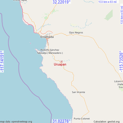
Uruapan GPS coordinates[2]
31° 37' 24.24" North, 116° 26' 18.168" West
| Map corner | latitude | longitude |
|---|---|---|
| Upper-left | 32.22019°, | -117.14151° |
| Center: | 31.6234°, | -116.43838° |
| Lower-right: | 31.02276°, | -115.73526° |
| Map W x H: | 133.1×133.1 km | = 82.7×82.7mi |
| max Lat: | 32.7° ⇑0.8% North |
| Uruapan: | 31.6234° |
| min Lat: | ⇓99.2% South 14.53588° |
| min Long | Uruapan | max Long |
| -117.105° | -116.43838° | -86.73105° |
| W 0.4%⇐ | ⇒99.6% E |
Elevation
Elevation of Uruapan is 204 m = 669 ft, and this is 1049.7 m = 3444 ft below average elevation for this country.
| Max E: |
3497 m = 11473 ft | 75.5% |
| Avg. | 1253.7 m = 4113 ft | |
| Uruapan | 204 m = 669 ft | |
Min E: |
-1 m = -3 ft | 24.5% |
See also: Mexico elevation on elevation.city.
Geographical zone
Uruapan is located in North temperate zone (between Tropic of Cancer and the Arctic Circle). Distance of this Northern Tropic circle is 910.3 km =565.6 mi to South.| Distance of | km | miles | from Uruapan |
|---|---|---|---|
| North Pole | 6490.9 | 4033.3 | to North |
| Arctic Circle | 3885 | 2414 | to North |
| Tropic Cancer | 910.3 | 565.6 | to South |
| Equator | 3516.2 | 2184.9 | to South |


Nearby cities:
15 places around Uruapan: (largest is in red/bold)
• Artículo Ciento Quince
52.5 km =32.6 mi,  345°
345°
• Benito García (El Zorrillo)
8.7 km =5.4 mi,  307°
307°
• Colonia Esperanza (Cañón San Carlos)
18.1 km =11.2 mi,  324°
324°
• Colonia Gómez Morín
30.4 km =18.9 mi,  340°
340°
• El Porvenir
53.3 km =33.1 mi, 340°
• El Sauzal de Rodríguez
38.4 km =23.9 mi, 321°
• Ensenada
31.6 km =19.6 mi,  330°
330°
• Fraccionamiento del Valle
36.2 km =22.5 mi,  27°
27°
• Héroes de la Independencia
51.8 km =32.2 mi,  91°
91°
• Rancho Verde
35.5 km =22.1 mi, 336°
• Rodolfo Sánchez Taboada
16.7 km =10.4 mi, 310°
• Salvador Rosas Magallón
32.6 km =20.3 mi, 341°
• San Rafael
32.8 km =20.4 mi, 340°
• San Vicente
37.8 km =23.5 mi,  151°
151°
• Villa de Juárez
43.6 km =27.1 mi, 332°
Sources, notices
• [Note1] Compared only with cities in Mexico existing in our database
• [Src1] Map data: © OpenStreetMap contributors (CC-BY-SA)
• [Src2] Other city data from geonames.org with taken over terms of usage.
• [Src3] Geographical zone / Annual Mean Temperature by Robert A. Rohde @ Wikipedia
