Manuel Ávila Camacho geodata
Manuel Ávila Camacho (Hidalgo) is a populated place; located in Mexico in America/Mexico_City (GMT-6) time zone. With population of 2,738 people, there are 3230 cities with bigger population in this country. Compared to other cities in Mexico, 59.4% of cities are located further ↓South; 55% of cities are located further ←West and 92.3% of cities have lower elevation than Manuel Ávila Camacho. Note1
Current local time in Manuel Ávila Camacho:
06:53 AM, WednesdayDifference from your time zone: hours


Manuel Ávila Camacho GPS coordinates[2]
20° 6' 42.984" North, 98° 42' 24.984" West
| Map corner | latitude | longitude |
|---|---|---|
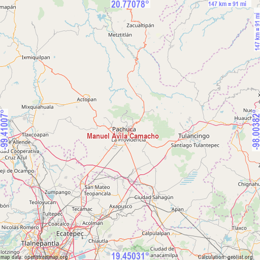
| Upper-left | 20.77078°, | -99.41007° |
| Center: | 20.11194°, | -98.70694° |
| Lower-right: | 19.45031°, | -98.00382° |
| Map W x H: | 146.8×146.8 km | = 91.2×91.2mi |
| max Lat: | 32.7° ⇑40.6% North |
| Manuel Ávila Camacho: | 20.11194° |
| min Lat: | ⇓59.4% South 14.53588° |
| min Long | Manuel Ávila C | max Long |
| -117.105° | -98.70694° | -86.73105° |
| W 55%⇐ | ⇒45% E |
Elevation
Elevation of Manuel Ávila Camacho is 2499 m = 8199 ft, and this is 1245.3 m = 4086 ft above average elevation for this country.
| Max E: |
3497 m = 11473 ft | 7.7% |
| Manuel Ávila Camacho | 2499 m 8199 ft | |
| Avg. | 1253.7 m = 4113 ft | |
Min E: |
-1 m = -3 ft | 92.3% |
See also: Mexico elevation on elevation.city.
Geographical zone
Manuel Ávila Camacho is located in North Torrid zone (between Equator and Tropic of Cancer). Distance of this Northern Tropic circle is 369.7 km =229.7 mi to North.| Distance of | km | miles | from Manuel Ávila Camacho |
|---|---|---|---|
| North Pole | 7770.8 | 4828.5 | to North |
| Arctic Circle | 5164.9 | 3209.3 | to North |
| Tropic Cancer | 369.7 | 229.7 | to North |
| Equator | 2236.2 | 1389.5 | to South |


Nearby cities:
15 places around Manuel Ávila Camacho: (largest is in red/bold)
• Campestre Villas del Álamo
1.1 km =0.7 mi,  181°
181°
• Carboneras
2.4 km =1.5 mi, 175°
• Colonia Militar
0.4 km =0.2 mi,  98°
98°
• El Álamo
2 km =1.2 mi,  192°
192°
• Guadalupe Minerva
1.7 km =1.1 mi,  334°
334°
• Pachuca de Soto
2.8 km =1.7 mi,  281°
281°
• Privada del Álamo
1.7 km =1.1 mi,  155°
155°
• Privadas de San Javier
2.1 km =1.3 mi,  221°
221°
• Real de Oriente
2 km =1.2 mi,  251°
251°
• Rio de la Soledad
0.6 km =0.4 mi,  303°
303°
• San Guillermo la Reforma
1.3 km =0.8 mi,  43°
43°
• Santiago Jaltepec
0.5 km =0.3 mi,  240°
240°
• Unidad Habitacional CTM
1.9 km =1.2 mi,  228°
228°
• Unidad Minera 11 de Julio
1.8 km =1.1 mi, 244°
• Álamo Rustico
1.5 km =0.9 mi, 217°
Sources, notices
• [Note1] Compared only with cities in Mexico existing in our database
• [Src1] Map data: © OpenStreetMap contributors (CC-BY-SA)
• [Src2] Other city data from geonames.org with taken over terms of usage.
• [Src3] Geographical zone / Annual Mean Temperature by Robert A. Rohde @ Wikipedia
