San Miguel Tianguizolco geodata
San Miguel Tianguizolco (Puebla) is a populated place; located in Mexico in America/Mexico_City (GMT-6) time zone. With population of 2,364 people, there are 3734 cities with bigger population in this country. Compared to other cities in Mexico, 62% of cities are located further ↑North; 58.1% of cities are located further ←West and 88.5% of cities have lower elevation than San Miguel Tianguizolco. Note1
Current local time in San Miguel Tianguizolco:
12:30 PM, MondayDifference from your time zone: hours


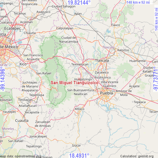
San Miguel Tianguizolco GPS coordinates[2]
19° 9' 30.996" North, 98° 26' 26.988" West
| Map corner | latitude | longitude |
|---|---|---|
| Upper-left | 19.82144°, | -99.14396° |
| Center: | 19.15861°, | -98.44083° |
| Lower-right: | 18.4931°, | -97.73771° |
| Map W x H: | 147.7×147.7 km | = 91.8×91.8mi |
| max Lat: | 32.7° ⇑62% North |
| San Miguel Tianguizolco: | 19.15861° |
| min Lat: | ⇓38% South 14.53588° |
| min Long | San Miguel Tian | max Long |
| -117.105° | -98.44083° | -86.73105° |
| W 58.1%⇐ | ⇒41.9% E |
Elevation
Elevation of San Miguel Tianguizolco is 2358 m = 7736 ft, and this is 1104.3 m = 3623 ft above average elevation for this country.
| Max E: |
3497 m = 11473 ft | 11.5% |
| San Miguel Tianguizolco | 2358 m 7736 ft | |
| Avg. | 1253.7 m = 4113 ft | |
Min E: |
-1 m = -3 ft | 88.5% |
See also: Mexico elevation on elevation.city.
Geographical zone
San Miguel Tianguizolco is located in North Torrid zone (between Equator and Tropic of Cancer). Distance of this Northern Tropic circle is 475.7 km =295.6 mi to North.| Distance of | km | miles | from San Miguel Tianguizolco |
|---|---|---|---|
| North Pole | 7876.8 | 4894.4 | to North |
| Arctic Circle | 5270.9 | 3275.2 | to North |
| Tropic Cancer | 475.7 | 295.6 | to North |
| Equator | 2130.2 | 1323.6 | to South |


Nearby cities:
15 places around San Miguel Tianguizolco: (largest is in red/bold)
• Cháhuac
4.4 km =2.7 mi,  158°
158°
• Domingo Arenas
2.7 km =1.7 mi,  218°
218°
• Huejotzingo
3.4 km =2.1 mi,  89°
89°
• Los Encinos
5 km =3.1 mi,  62°
62°
• Pueblo Nuevo
5.8 km =3.6 mi,  178°
178°
• San Andrés Calpan
6.5 km =4 mi,  199°
199°
• San Antonio Tlatenco
6.4 km =4 mi,  284°
284°
• San Diego Buenavista
5.1 km =3.2 mi,  233°
233°
• San Juan Pancoac
1.1 km =0.7 mi,  186°
186°
• San Lorenzo Chiautzingo
5.8 km =3.6 mi,  331°
331°
• San Luis Coyotzingo
4.4 km =2.7 mi,  5°
5°
• San Mateo Capultitlán
4.9 km =3 mi,  33°
33°
• Santa María Atexcac
6.4 km =4 mi,  246°
246°
• Santa María Nepopualco
5.3 km =3.3 mi,  260°
260°
• Santa María Tianguistenco
0.4 km =0.2 mi, 246°
Sources, notices
• [Note1] Compared only with cities in Mexico existing in our database
• [Src1] Map data: © OpenStreetMap contributors (CC-BY-SA)
• [Src2] Other city data from geonames.org with taken over terms of usage.
• [Src3] Geographical zone / Annual Mean Temperature by Robert A. Rohde @ Wikipedia
