Dolores geodata
Dolores (Guanajuato) is a populated place; located in Mexico in America/Mexico_City (GMT-6) time zone. With population of 929 people, there are 9387 cities with bigger population in this country. Compared to other cities in Mexico, 75.7% of cities are located further ↓South; 80.3% of cities are located further →East and 61.6% of cities have lower elevation than Dolores. Note1


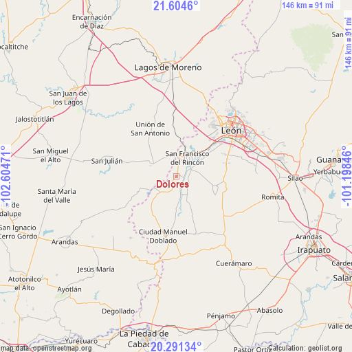
Dolores GPS coordinates[2]
20° 56' 57.876" North, 101° 54' 5.688" West
| Map corner | latitude | longitude |
|---|---|---|
| Upper-left | 21.6046°, | -102.60471° |
| Center: | 20.94941°, | -101.90158° |
| Lower-right: | 20.29134°, | -101.19846° |
| Map W x H: | 146×146 km | = 90.7×90.7mi |
| max Lat: | 32.7° ⇑24.3% North |
| Dolores: | 20.94941° |
| min Lat: | ⇓75.7% South 14.53588° |
| min Long | Dolores | max Long |
| -117.105° | -101.90158° | -86.73105° |
| W 19.7%⇐ | ⇒80.3% E |
Elevation
Elevation of Dolores is 1752 m = 5748 ft, and this is 498.3 m = 1635 ft above average elevation for this country.
| Max E: |
3497 m = 11473 ft | 38.4% |
| Dolores | 1752 m 5748 ft | |
| Avg. | 1253.7 m = 4113 ft | |
Min E: |
-1 m = -3 ft | 61.6% |
See also: Mexico elevation on elevation.city.
Geographical zone
Dolores is located in North Torrid zone (between Equator and Tropic of Cancer). Distance of this Northern Tropic circle is 276.6 km =171.9 mi to North.| Distance of | km | miles | from Dolores |
|---|---|---|---|
| North Pole | 7677.7 | 4770.7 | to North |
| Arctic Circle | 5071.8 | 3151.5 | to North |
| Tropic Cancer | 276.6 | 171.9 | to North |
| Equator | 2329.4 | 1447.4 | to South |


Nearby cities:
15 places around Dolores: (largest is in red/bold)
• Cañada de Negros
3.3 km =2.1 mi,  218°
218°
• El Maguey
6.7 km =4.2 mi,  58°
58°
• El Refugio
1.6 km =1 mi,  17°
17°
• El Tecolote
7.6 km =4.7 mi,  198°
198°
• Fraccionamiento Villa Jardín
7 km =4.3 mi,  47°
47°
• Monte Grande
6.7 km =4.2 mi,  36°
36°
• Peñuelas
9.2 km =5.7 mi,  146°
146°
• San Bernardo
3.9 km =2.4 mi, 58°
• San Francisco del Rincón
9.1 km =5.7 mi,  32°
32°
• San Ignacio de Hidalgo
6 km =3.7 mi,  134°
134°
• San Jerónimo
5.4 km =3.4 mi, 30°
• San Nicolás del Palenque
4 km =2.5 mi,  358°
358°
• San Roque de Torres
5.6 km =3.5 mi, 64°
• San Ángel
5.6 km =3.5 mi, 198°
• Silva
4.7 km =2.9 mi,  94°
94°
Sources, notices
• [Note1] Compared only with cities in Mexico existing in our database
• [Src1] Map data: © OpenStreetMap contributors (CC-BY-SA)
• [Src2] Other city data from geonames.org with taken over terms of usage.
• [Src3] Geographical zone / Annual Mean Temperature by Robert A. Rohde @ Wikipedia
