Mecoacán 2da. Sección (San Lorenzo) geodata
Mecoacán 2da. Sección (San Lorenzo) (Tabasco) is a populated place; located in Mexico in America/Mexico_City (GMT-6) time zone. With population of 1,807 people, there are 4820 cities with bigger population in this country. Compared to other cities in Mexico, 75.2% of cities are located further ↑North; 88.2% of cities are located further ←West and 96.3% of cities have higher elevation than Mecoacán 2da. Sección (San Lorenzo). Note1
Current local time in Mecoacán 2da. Sección (San Lorenzo):
06:48 AM, WednesdayDifference from your time zone: hours


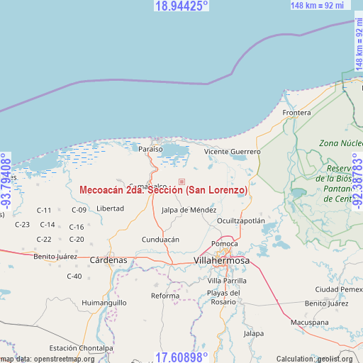
Mecoacán 2da. Sección (San Lorenzo) GPS coordinates[2]
18° 16' 40.44" North, 93° 5' 27.42" West
| Map corner | latitude | longitude |
|---|---|---|
| Upper-left | 18.94425°, | -93.79408° |
| Center: | 18.2779°, | -93.09095° |
| Lower-right: | 17.60898°, | -92.38783° |
| Map W x H: | 148.5×148.5 km | = 92.3×92.3mi |
| max Lat: | 32.7° ⇑75.2% North |
| Mecoacán 2da. Sección (San Lorenzo): | 18.2779° |
| min Lat: | ⇓24.8% South 14.53588° |
| min Long | Mecoacán 2da. | max Long |
| -117.105° | -93.09095° | -86.73105° |
| W 88.2%⇐ | ⇒11.8% E |
Elevation
Elevation of Mecoacán 2da. Sección (San Lorenzo) is 11 m = 36 ft, and this is 1242.7 m = 4077 ft below average elevation for this country.
| Max E: |
3497 m = 11473 ft | 96.3% |
| Avg. | 1253.7 m = 4113 ft | |
| Mecoacán 2da. Sección (San Lorenzo) | 11 m = 36 ft | |
Min E: |
-1 m = -3 ft | 3.7% |
See also: Mexico elevation on elevation.city.
Geographical zone
Mecoacán 2da. Sección (San Lorenzo) is located in North Torrid zone (between Equator and Tropic of Cancer). Distance of this Northern Tropic circle is 573.6 km =356.4 mi to North.| Distance of | km | miles | from Mecoacán 2da. Sección (San Lorenzo) |
|---|---|---|---|
| North Pole | 7974.7 | 4955.2 | to North |
| Arctic Circle | 5368.9 | 3336.1 | to North |
| Tropic Cancer | 573.6 | 356.4 | to North |
| Equator | 2032.3 | 1262.8 | to South |


Nearby cities:
15 places around Mecoacán 2da. Sección (San Lorenzo): (largest is in red/bold)
• Ayapa
6.4 km =4 mi,  200°
200°
• Cupilco
5.8 km =3.6 mi,  222°
222°
• El Novillero
3.1 km =1.9 mi,  182°
182°
• El Recreo
0.4 km =0.2 mi,  326°
326°
• La Ensenada
5.7 km =3.5 mi, 177°
• La Trinidad
4.9 km =3 mi,  157°
157°
• Mecoacán
4.5 km =2.8 mi,  167°
167°
• Nicolás Bravo
4.5 km =2.8 mi,  290°
290°
• Nicolás Bravo 5ta. Sección (Punta Brava)
4 km =2.5 mi,  270°
270°
• Novillero 4ta. Sección
4.5 km =2.8 mi,  214°
214°
• Potrerillo
5.3 km =3.3 mi,  240°
240°
• San Simón
7.5 km =4.7 mi,  127°
127°
• Soyataco
7.8 km =4.8 mi, 166°
• Tecoluta 2da. Sección
8.4 km =5.2 mi,  116°
116°
• Uspí
4.7 km =2.9 mi,  227°
227°
Sources, notices
• [Note1] Compared only with cities in Mexico existing in our database
• [Src1] Map data: © OpenStreetMap contributors (CC-BY-SA)
• [Src2] Other city data from geonames.org with taken over terms of usage.
• [Src3] Geographical zone / Annual Mean Temperature by Robert A. Rohde @ Wikipedia
